
INTRODUCTION
Paleogene shallow-water successions are widespread throughout the peri-Mediterranean area and consist of lithified marine sediments rich in larger Foraminifera, corals, and red algae (e.g., Pignatti, 1995; Ćosović et al., 2004; Scheibner & Speijer, 2008). Such depositional environments have been interpreted as carbonate ramps (Accordi et al., 1998; Vecsei et al., 1999; Ćosović et al., 2018; Briguglio et al., 2023). Key biological and climate events, such as the benthic aftermath of the Cretaceous-Paleocene (K-Pg) mass extinction and the hyperthermal event at the Paleocene-Eocene boundary (PETM; see Zamagni et al., 2012) are recorded along. A great diversity for larger Foraminifera is observed already soon after the K-Pg (Drobne et al., 2014; Sinanoğlu et al., 2022) and throughout the whole Paleocene and Eocene (Hottinger, 2001; Benedetti & Papazzoni, 2022) punctuated by repeated bioevents, used in biostratigraphy for the identification of standard biozones, named Shallow Benthic Zones (Serra-Kiel et al., 1998) that are, for the Paleocene, also calibrated with the calcareous nannofossil biostratigraphic scale (SBP; Papazzoni et al., 2023).
In this paper, we carried out a detailed stratigraphic sampling of the Eocene shallow-water carbonate succession exposed in the Val Rosandra gorge, near Trieste, and included in sheet 110 “Trieste” of the new geological map of Italy released in the frame of the CARG Project (geologic and geothematic cartography of Italy at 1:50,000). The Eocene rocks widely crop out in the gorge, but field conditions make logging at times complex as sections are often of difficult accessibility because of steep cliffs, complex structural settings and thick vegetation. For this reason, here classical fieldwork is coupled with drone imagery and virtual outcrop modeling to perform accurate logging and samples’ geotagging. The advent of three-dimensional virtual outcrop modeling techniques has offered new possibilities to accurately collect data from outcrops (e.g., Marques et al., 2020; Seers et al., 2021). Among the techniques to produce virtual outcrop models, structure from motion–multiview stereo (SfM-MVS) digital photogrammetry (e.g., Arbués et al., 2012; James & Robson, 2012; Favalli et al., 2012; Bemis et al., 2014; Tavani et al., 2014), particularly thanks to the advances in drone imagery, has emerged as a flexible, precise and easy-to-use methodology. This technique has progressively been applied in diverse disciplines including structural geology (Franceschi et al., 2015; Corradetti et al., 2017; Camanni et al., 2021), fracture stratigraphy (Manniello et al., 2023), geomechanics (Menegoni et al., 2019; Furlani et al., 2022; Schilirò et al., 2022; Mammoliti et al., 2023), geomorphology (Brodu & Lague, 2012; Carrivick & Smith, 2019; Devoto et al., 2020) stratigraphy (Nesbit et al., 2018) and sedimentology (Fabuel-Perez et al., 2010; Jablonska et al., 2021) among many others.
Stratigraphic sampling in the field and data release are usually framed by sketch drawings/taking pictures at the sample locality, the associated coordinate position of the base of the stratigraphic sections, logging, and, in some cases, granting access to samples. Geological field activities and field data documentation and distribution can be significantly improved where the work is supported by 3D digital modeling techniques as they may allow, for instance, accurate positioning of measurements/observations, imaging of areas that are of difficult accessibility, identification of the best sampling path, digital documentation of the examined outcrop through time.
The objective of this study is threefold: (i) demonstrate the potential advantages offered by the integration of virtual outcrop modeling in stratigraphic investigations; (ii) build a potential reference section for the Eocene lithostratigraphic unit outcropping in the area which is included in the sheet 110 (Trieste) of the CARG project; (iii) provide a detailed biostratigraphic frame of the sampled section by applying SBZs, mostly based on the vertical range of species of the foraminiferal genera Alveolina, and, secondarily, on plankton biozonation for the hemipelagic portion.
The present paper provides a brief and comprehensive contribution to the use of drone imagery as support in classic stratigraphic fieldwork. We discuss the implications of using drones during fieldwork and the potential advantages of having a virtual outcrop model at hand when constructing a stratigraphic section and studying an outcrop. Moreover, results of biostratigraphic and facies investigations allow framing the studied succession within the general evolution of the Adriatic Carbonate Platform during the Eocene.
Finally, the application of 3D virtual outcrop modeling techniques provides quantitative information (e.g., the trace of the sampled section, the position of each sample, and the bedding attitude) that could potentially be used to enrich the CARG project digital database.
GEOLOGICAL SETTING AND STRATIGRAPHY
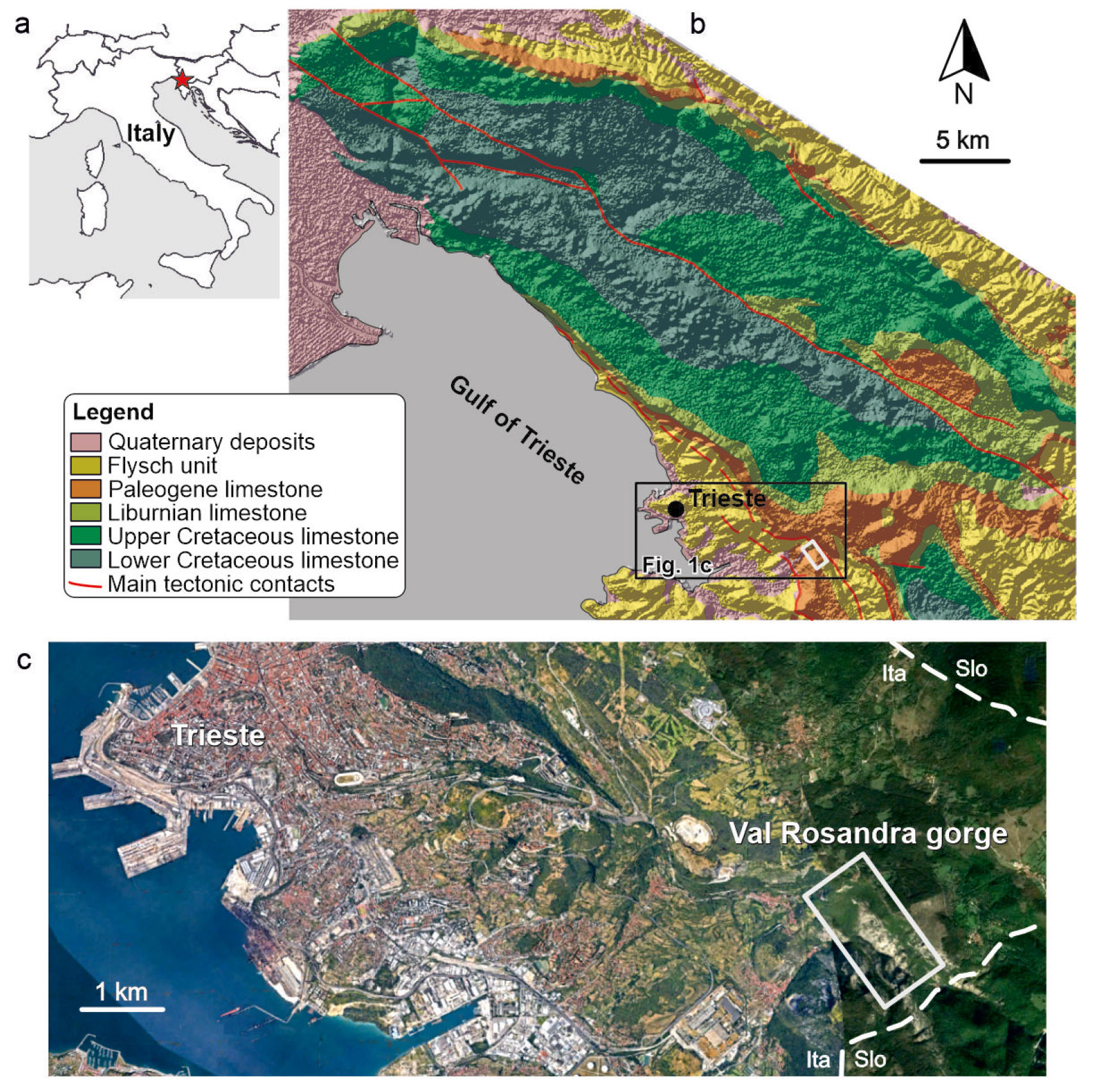
The studied outcrop is located in the municipality of San Dorligo della Valle/Dolina, near the city of Trieste (Italy) and next to the Slovenian border where the Rosandra Gorge originates (Fig. 1). From the structural point of view, the area belongs to the northwestern sector of the External Dinarides (e.g., Otoničar, 2007). The latter is a fold-and-thrust belt formed during the NE-SW-oriented Jurassic-Eocene convergence between the European and Adria-related units (Schmid et al., 2008; van Unen et al., 2019; van Hinsbergen et al., 2020). In this region, the most obvious result of such convergence is the iconic Kras-Carso plateau, made of rocks belonging to the Adriatic Carbonate Platform (AdCP; “sensu lato” in Korbar, 2009; Vlahović et al., 2005; Jurkovšek et al., 2016; Consorti et al., 2021), which extends in a northwest–southeast direction (Fig. 1b). During the Mesozoic, the Kras-Carso was situated at the NW side of the wider AdCP that was part of the peri-Adriatic Mediterranean archipelago composed of isolated carbonate shelves bordered by deep basins. The shallow-water carbonate succession of the Kras-Carso plateau is composed of a thick pile (up to 1.5 km) of Mesozoic to lower Eocene shallow-water carbonates – mainly limestone and, in minor proportions, dolostone and breccia, and a middle Eocene siliciclastic succession containing sparse carbonate olistoliths (Jurkovšek et al., 2016). The lithostratigraphy of these Meso-Cenozoic units has been proposed by several Authors, to which we refer for further reading (e.g., Cucchi et al., 1987; Vlahović et al., 2005; Korbar, 2009; Jurkovšek et al., 2016; Consorti et al., 2021). The studied section encompasses the upper part of the “miliolids, Alveolina and Nummulites limestone” sensu Consorti et al. (2021), referable to the “Alveolinid-Nummulitid limestone” of Jurkovšek et al. (2016), or “Foraminiferal limestone” of Vlahović et al. (2005) and Korbar (2009), which age spans, in the Kras-Carso, through the mid Paleocene and the early Eocene. The Eocene successions of the AdCP can be also found in the subsurface of the Friuli region (there called Friuli Platform), in Slovenia and along the coast of Croatia, in Bosnia and Montenegro (Drobne et al., 2011; Ibrahimpašić et al., 2015; Ćosović et al., 2018, among others). The drowning of the Eocene carbonate succession is characterised by hemipelagic limestone facies containing planktonic Foraminifera like Acarinina, Subbotina (see Ibrahimpašić et al., 2015). This is followed by a thick succession of foredeep siliciclastic deposits, referred to in the literature as “Transitional beds”, “Flysch” or “Promina deposits”, among other terms. These deposits may span from the middle Eocene to the Oligocene, indicating basin evolution associated with the Dinarid orogeny (Tari Kovačić and Mrinjek, 1994; Korbar, 2009).
- (a) Map of Italy with the position of the studied area (red star). (b) Simplified geological map of the Karst Region, simplified from Jurkovšek et alii (2016). (c) Position of the Val Rosandra gorge within the Trieste municipality (taken from Google Earth).
MATERIALS AND METHODS
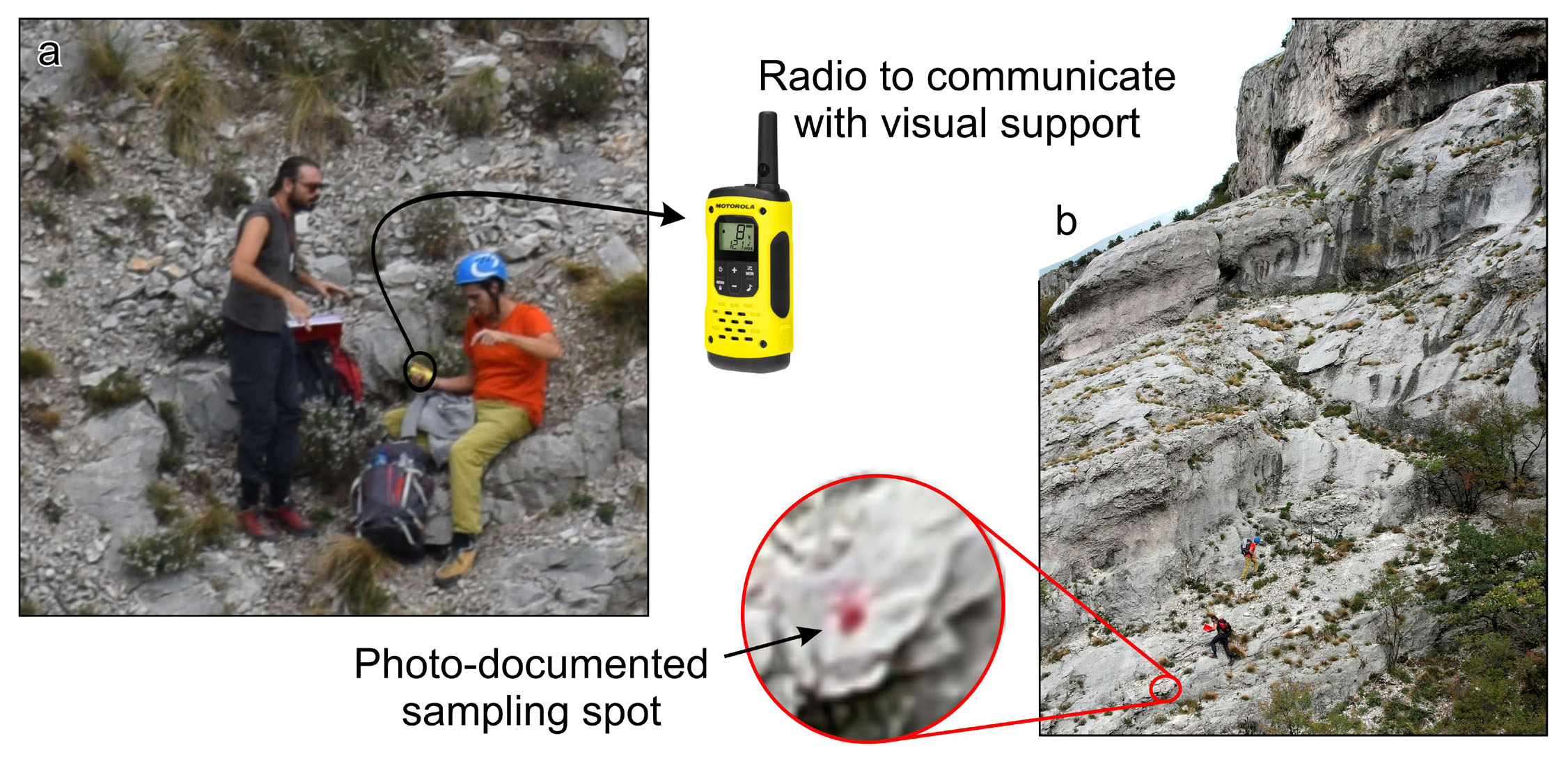
The fieldwork was carried out in early October 2022. Logging and sampling were made working on the outcrops located on the northern flank of the gorge. (Fig. 2a and b). On the southern side of the gorge, from a panoramic point of view, visual support was provided and an aerial photo acquisition of the section was carried out by means of an Uncrewed Aerial Vehicle (UAV) device, aka a drone. The two teams were in radio contact (Fig. 2a).
- Images collected during the visual support to the team sampling the stratigraphic column. The two teams were in radio contact (a). (b) Image showing one of the stratigraphic sampling positions that was marked with a red dot on the outcrop.
Field data acquisition and analysis
Equipped with the traditional tools of field geologists (hammer, lens, ruler, and notebook), the first team started sampling the succession from the lower portion of the gully up to the cyclable-pedestrian track along the former Trieste-Erpelle railway track. Limestone samples (labeled VR-) were collected by walking straight across the beds to build the reference stratigraphic column, samples were taken with a spacing of about 1 to 2 metres; a total of 73 samples were collected along the stratigraphic column. Additional 20 scattered foraminiferal-rich limestone samples (labeled AC-) were collected from the northern side of the gorge and surrounding areas. Thin sections and polished slabs were prepared from the samples; facies were defined in terms of texture, components and palaeoenvironmental meaning according to Flügel (2010) and Ćosović et al. (2004; 2018) for specific reference to the Paleogene of the AdCP. Samples’ foraminiferal content was photographed with a microscope digital camera using both transmitted and reflected light, whereas we used (mostly but not exclusively) Hottinger (1974), Serra-Kiel et al. (1998), Drobne et al. (2009; 2011) and Ibrahimpašić et al. (2015) for taxonomic discriminations and biostratigraphy.
Due to the mentioned difficult accessibility and vegetation and debris cover, the logging and sampling were carried out following discrete paths, with the aim of then merging collected data together as a composite section into a synthetic stratigraphic column. Constant radio support was hence necessary to guide the team during the work. The support team provided guidance to choose the path in order to guarantee continuous composite sampling.
Drone imaging and visual support
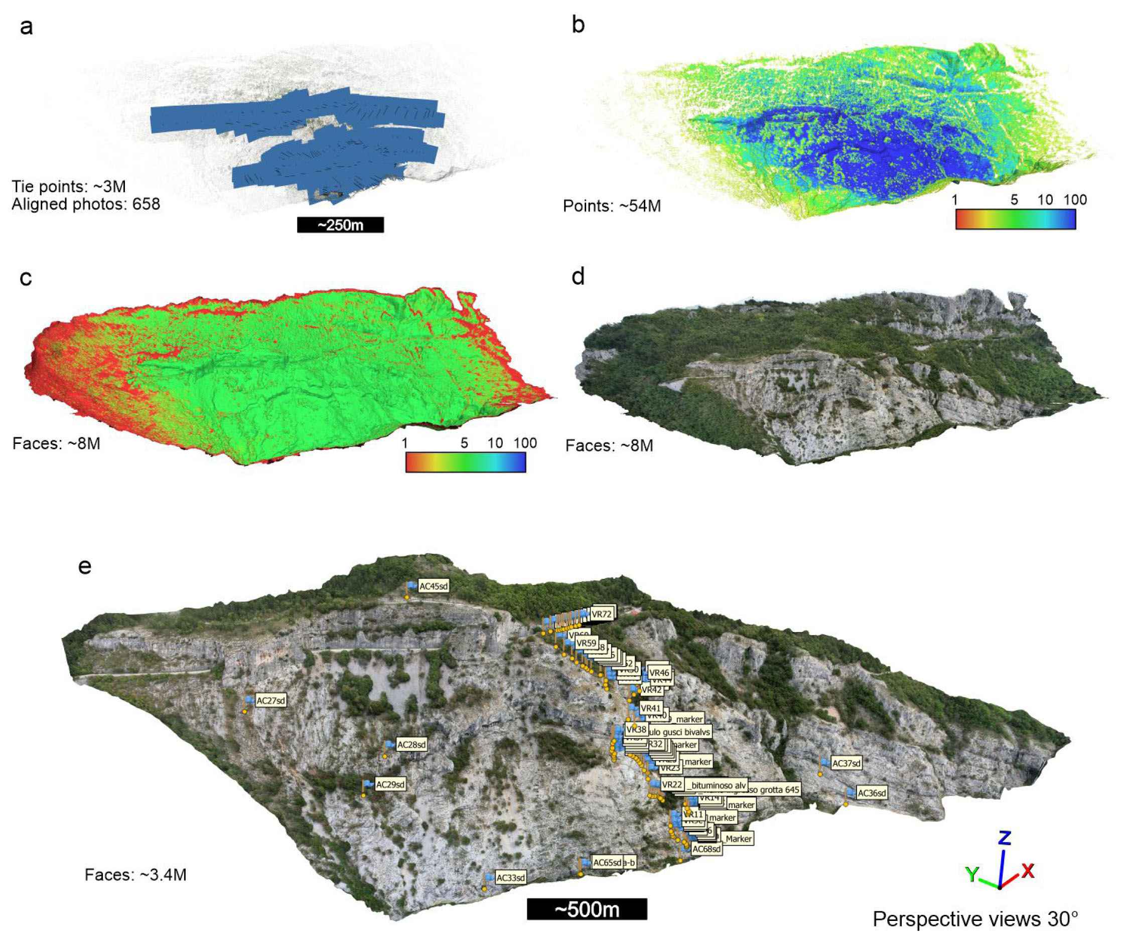
The drone used for the photo acquisition is a DJI Air 2S. This model has an embedded GNSS positioning system (GPS, GLONASS, and Galileo constellations), a compass, and an inertial measurement unit (IMU) allowing a hovering accuracy range of vertical and horizontal positioning with GNSS of ~0.5 m and ~1.5 m respectively. The DJI Air 2S has a 20-megapixel camera with a 1” CMOS sensor, mounted on a three-axis gimbal. A total of 658 photos were collected in JPG format (5472 × 3648 pixels) in manual flight mode, prioritizing image overlap along the sampling path (Fig. 3a). The lens angle of view is 22 mm (35 mm equivalent).
- Perspective views of the northern side of the Val Rosandra gully. (a) Tie-points cloud with camera positions. (b) Filtered-dense cloud coloured by point confidence assigned by Metashape. (c) Mesh model with faces coloured by confidence assigned by Metashape; note that red faces correspond to extrapolated areas from the dense cloud. (d) Textured model with sampling points. (e) High-confidence textured model of the stratigraphic section. Models in a, b, c, and d have the same scale, while all the models (including model e) share the same perspective point of view.
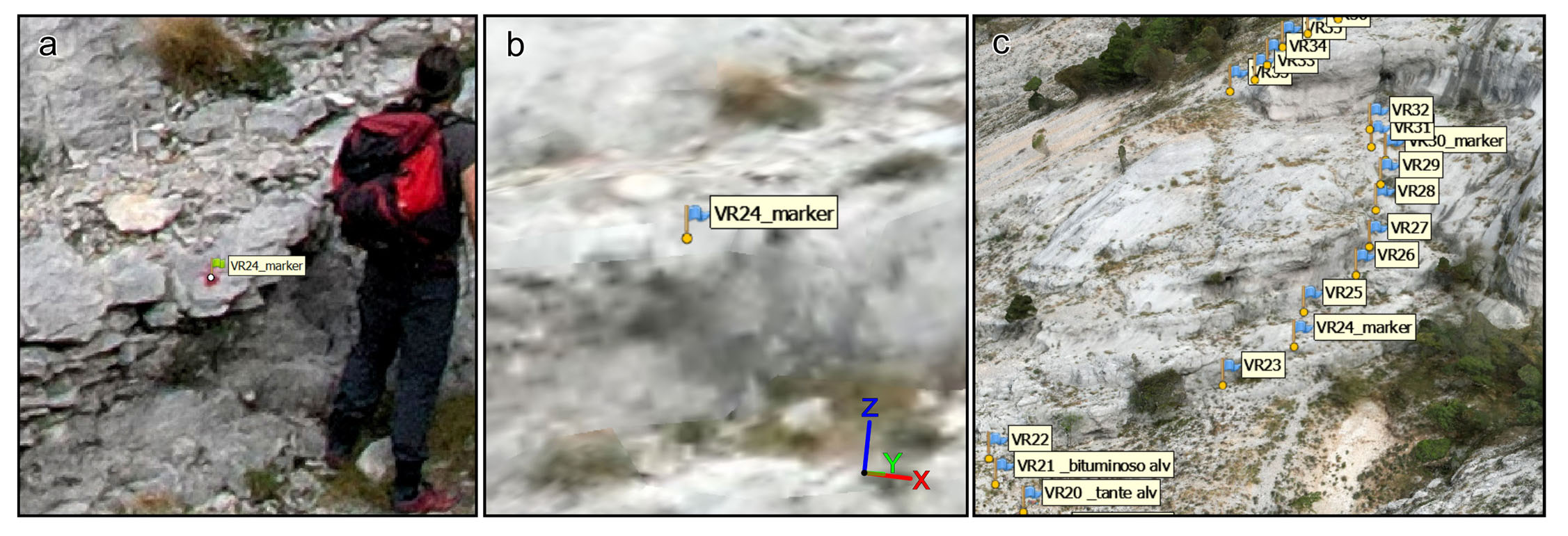
While guiding the team working along the section and operating the drone, the support team was kept up to date with the sampling tag number so that, with the help of an iPad Pro, the position of the samples was noted over panoramic photographs of the cliff. Every now and then, the stratigraphic sampling position was marked with a red dot on the rock (Fig. 2b), which was promptly photographed from the drone or using a Single Lens Reflex (SLR) with a telephoto lens to preserve drone batteries. This documentation made by the support team was very important since the accurate geotag of the samples could not be resolved by the team in charge of the sampling using a handheld GNSS receiver. Indeed, a handheld GNSS receiver, like, for example, a smartphone, would not be resolutive enough on this very steep cliff since a small horizontal position uncertainty may lead to a very large vertical error.
3D virtual outcrop model construction and identification of sampling spots
The aerial photographs were processed in Agisoft Metashape software to build the virtual outcrop model of the northern side of the Val Rosandra gully. The well-known workflow of Metashape (Verhoeven, 2011; Tavani et al., 2014; Carrivick et al., 2016) involved the high-accuracy alignment of the photographs followed by an iterative gradual selection filtering and camera optimization steps leading to a final Tie-Point cloud made of ~3M points (Fig. 3a). The medium-quality densification returned a dense cloud made of ~54M points that were also filtered based on point confidence (Fig. 3b). The resulting mesh was computed at 8M faces (Fig. 3c) and textured (Fig. 3d). A tiled model was also generated to improve graphic resolution within Metashape. A smaller, high-confidence portion (Fig. 3c) of the modeled area, which includes the sampled section, was selected and retextured (Fig. 3e). Scaling and georeferencing of the model were granted by the image geotags acquired through the drone GNSS sensor. Typically, drones like the DJI Air 2S, when served by appropriate satellite coverage, have a few metres of error in position accuracy and high precision (Corradetti et al., 2022). This accuracy error can be considered negligible when the cameras’ positions are distributed over several hundreds of metres (Fig. 3a) (e.g., Menegoni et al., 2019; Panara et al., 2022). Larger errors typically resolve into very minor rigid translations in the latitude-longitude components that may become not negligible in the vertical component (Corradetti et al., 2022). Therefore, the Val Rosandra gorge model can be considered accurate enough with respect to its orientation and internal scale for the purpose of this work.
Since not all of the sampling spots were marked on the outcrop, their identification in Metashape occurred in two phases. First, all marked spots were identified in the model from the aligned images (Fig. 4a). In essence, the spots were identified from the images and Metashape repositioned them in the 3D space (Fig. 4b). The sampling spots that were not marked were positioned thanks to photographs and notes taken on the iPad from the visual supporting team with assistance from the surveyors who carried out the sampling. This procedure allowed identifying all the sampling spots in the 3D model (Fig. 3e; 4c).
- (a) Marker identification from aligned photographs in Metashape. (b) One of the markers that was automatically repositioned in the 3D space of Metashape. (c) Some markers corresponding to sampling points repositioned in the model.
The high-confidence 3D model of the northern side of the Val Rosandra gully (Fig. 3e) was exported for structural investigation. A lower-resolution version of the larger model (Fig. 3d) has been made available in public repositories like Sketchfab (https://skfb.lv/ovN6E) and V3Geo (Buckley et al., 2022) (https://v3geo.com/model/452). The aerial imagery also enabled the production of a high-resolution aerial orthoimage of the area, which can help the geological mapping. Unfortunately, the free basic subscription in Sketchfab does not allow annotations of more than 10 points, so we decided to only tag the beginning and end of the stratigraphic section in the model stored in Sketchfab. Likewise, V3Geo does not yet implement a shareable interpretation tool which is instead provided through the commercial software LIME (Buckley et al., 2019). Two *.kmz files providing sampled traces and sampled spots to be viewed on Google Earth are provided as supplementary material (Supplement 1 and Supplement 2). Note that mismatches exist between the Google Earth elevation model and the higher-resolution 3D model produced in this work from which the traces have been digitalized connecting sampled spots. Moreover, as detailed above, since the model was registered using only the image geotags provided by the drone, the elevations of the sampled spots should not be considered absolute elevations.
Data extraction and model orthorectification
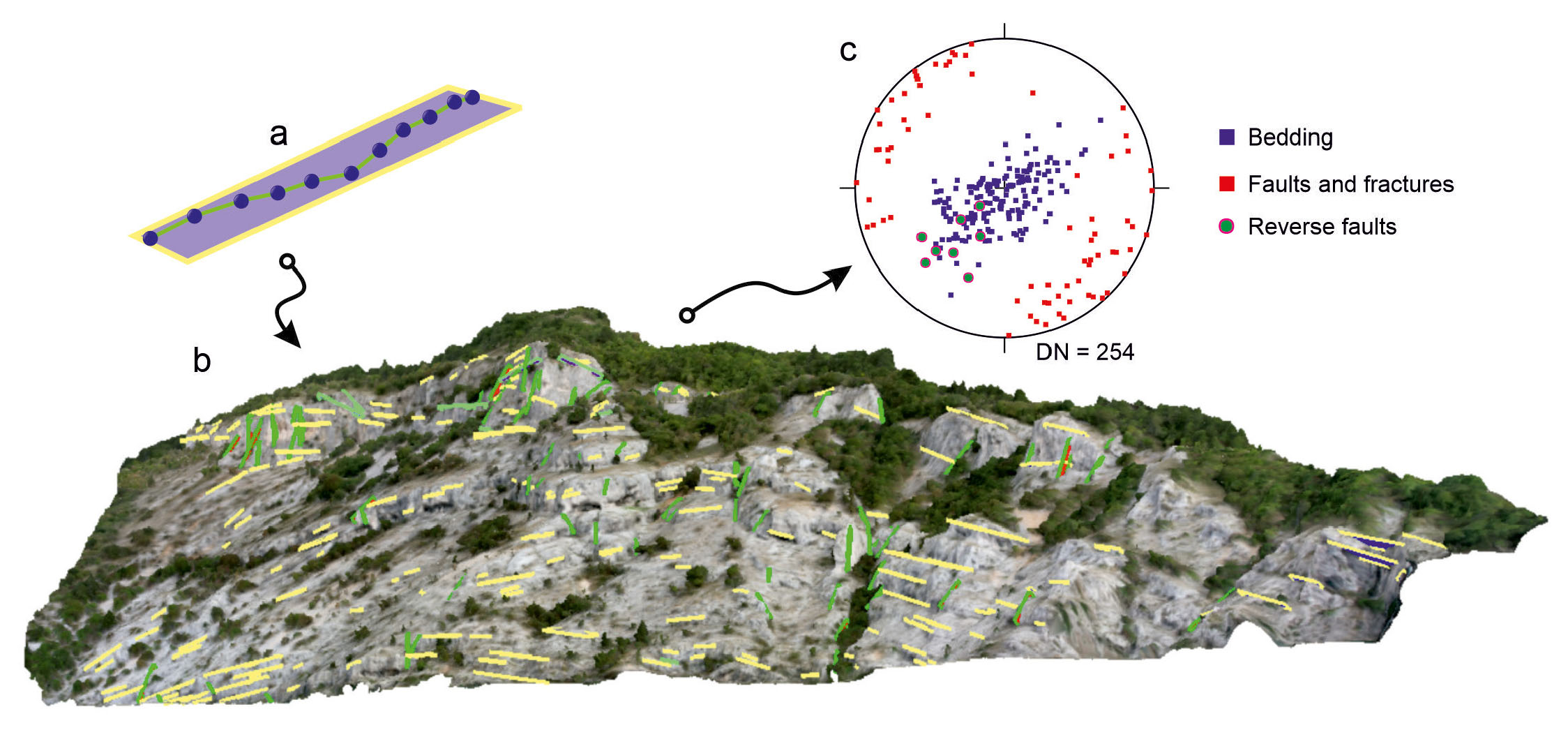
The textured outcrop mesh of the study area (Fig. 3e) was loaded in the recently released version of Openplot free software (v. 1.05; Tavani et al., 2011), where visible and well-expressed geological features were digitized. For details on the technical usage of Openplot readers are referred to available literature (e.g., Tavani et al., 2016; Corradetti et al., 2017). In short, the software uses digitized polylines to calculate best-fit planes in real-time (Fig. 5a), allowing the user to evaluate in 3D whether to reject or retain each plane. This visual evaluation is essential considering that it is a common user error the digitization of polylines that return best-fit planes that follow the outcrop topography rather than the penetrating geometry of the geological planar features of interest (e.g., Fernández et al., 2009; Jones et al., 2016; Seers and Hodgetts, 2016). Bedding planes, fractures, and faults that are well-expressed in the model were digitized (Fig. 5b-c). Bedding plane orientations were used to produce properly oriented orthoimages of the model that have been used to recalculate the bed thickness (e.g., Corradetti et al., 2017; Menegoni et al., 2018; Tavani et al., 2023), and to re-drawn the stratigraphic column as shown in the figure provided in the supplementary material (Supplement 3). In essence, properly oriented orthoimages are perpendicular to bedding photo-realistic cross sections of the 3D model, and thus thicknesses in orthoimages are the most reasonable approximation of stratigraphic thickness. The success of the orthorectification of the model and thus of the beds’ thickness calculation from the orthoimages relates to diverse factors. Among them, a major role is played by (i) the internal accuracy of the model (i.e., its scaling and its internal geometrical consistency), (ii) the coplanarity/collinearity factors of the digitized polylines (e.g., Fernández, 2005), and, in the case of folded strata, (iii) to the fold’s cylindricity.
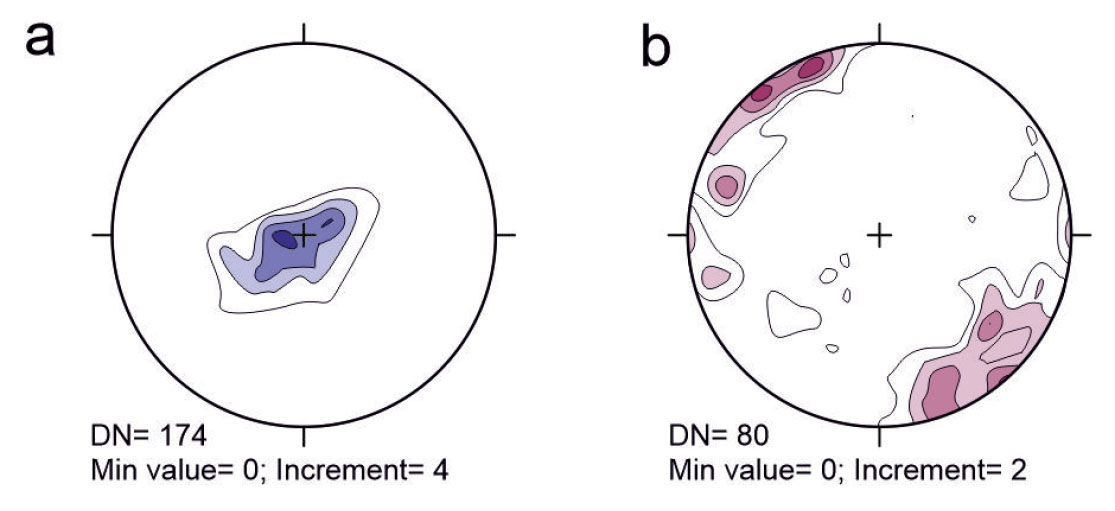
- (a) Example of a best-fit plane from a polyline. (b) Perspective view (30°) from the South of the virtual outcrop model interpreted in Openplot. Bedding planes are depicted as rectangles with a yellow outline, while faults and fractures have a green outline. (c) Lower hemisphere equal-area projections of poles to bedding and faults. DN is the number of planar features extracted.
RESULTS
Limestone facies and palaeoenvironment
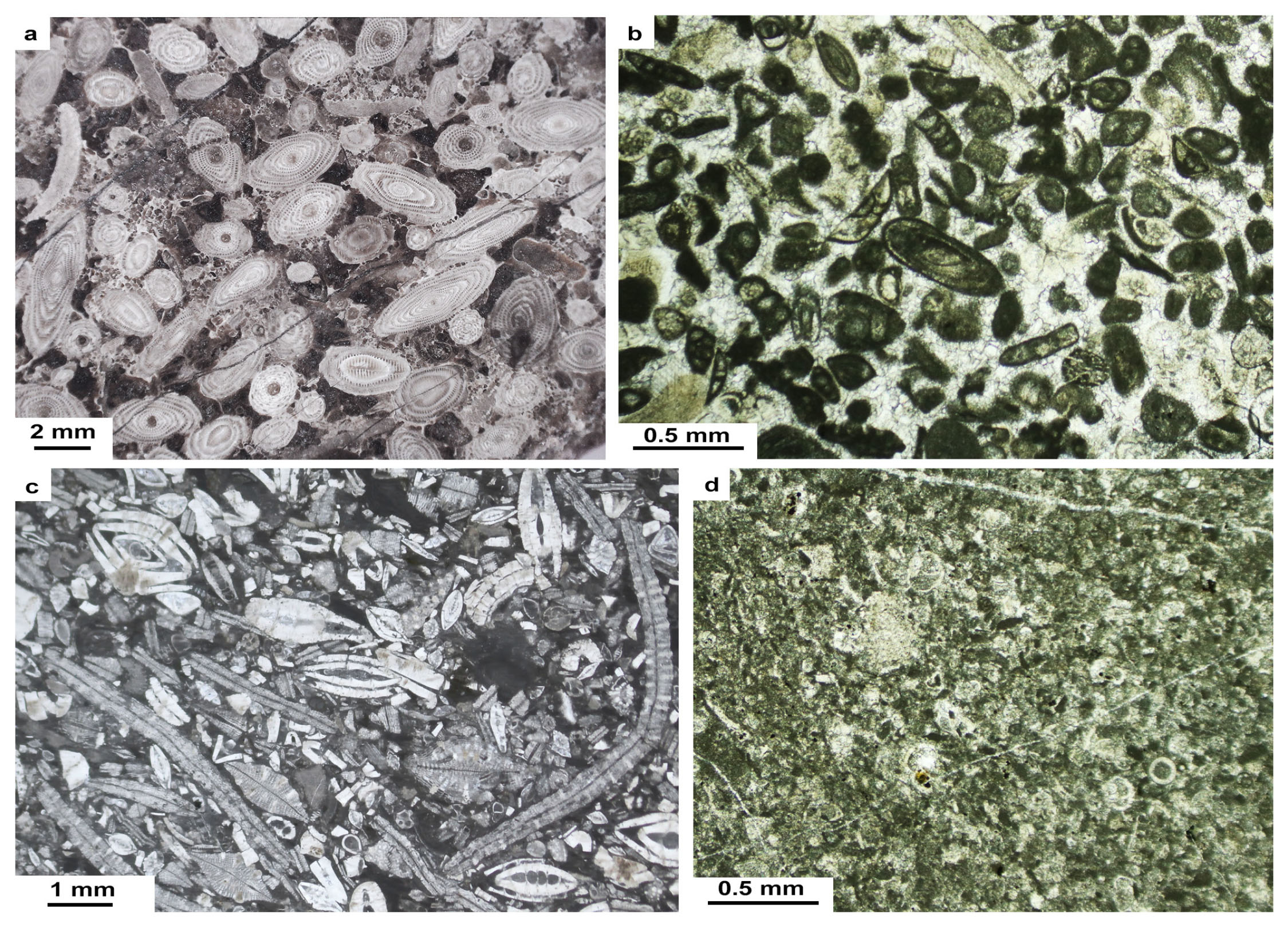
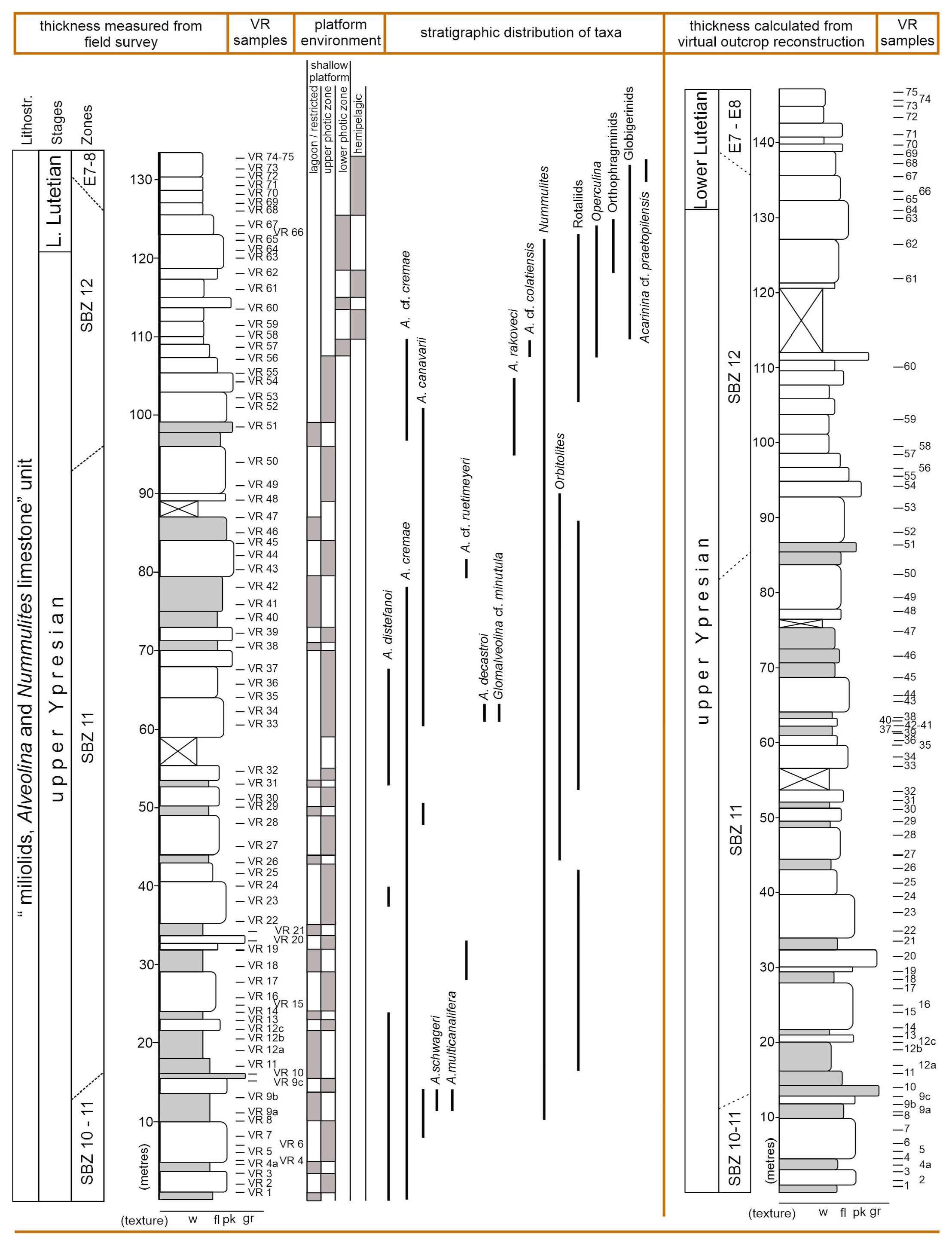
The thickness of the carbonate succession exposed in the Val Rosandra section and measured in the field was estimated in 132 metres. The first 107 metres are made of shallow-water facies. A rough subdivision into facies associations of this stratigraphic portion includes: i) miliolids and Alveolina grainstone (in some cases fine-grained) and packstone with subordinate rudstone. Components include other foraminiferal fragments (Nummulites, Orbitolites, smaller Foraminifera and rotaliids) and corallinacean red algae; ii) packstone to floatstone in which the main components are Alveolina, miliolids and other porcelaneous taxa (e.g., Spirolina sp.) and subordinate Nummulites, with few levels of fine-grained packstone/grainstone with miliolids and Cibicides (Fig. 6b). A dominance of porcelaneous taxa suggests deposition in a shallow ramp (Ćosović et al., 2004; Flügel, 2010) of an oligotrophic sea bottom within the photic zone at a very shallow depth (similar to facies MF1 and MF2 of Ćosović et al., 2018 in the AdCP, see also Romero et al., 2002). The characteristic Alveolina-rich accumulations (Fig. 6a) indicate indeed high energy above the mean fair-weather wave base, whose deposition is driven by intense winnowing under well-illuminated conditions (facies MF3 of Ćosović et al., 2018). These shallow-water facies alternate in the first 100 m of the section (Fig. 7). In several cases, the matrix of floatstone to packstone appears comparatively darker with traces of organic matter, suggesting proximal position of a restricted environment (e.g., lagoon). This possibly corresponds to the quasi-lagoonal environment of Ćosović et al. (2018) pointing to innermost ramp areas protected from waves by shoals or seagrass meadows. Upward in the section, through the last 25 metres of succession (Fig. 6c), fine-grained packstone with scarce planktonic foraminifera along with Nummulites-Operculina-orthophragminid packstone/floatstone with sparse fragments of and corallinacean red algae alternate throughout. Such facies change suggests that the depositional environment shifted to a deeper setting, into the lower photic zone of the mid-outer platform. This is especially denoted by planktonic foraminifera and the abundance of flat lamellar perforated larger foraminifera (Fig 6c). Among the latter, Operculina, whose Recent distribution in the water column is precisely constrained by the ecological requirements of algal symbionts hosted in the shell, indicates the lower photic zone (Hottinger et al., 1978, 1997; Leutenegger, 1984; Hohenegger, 2000). Planktonic foraminifera become abundant, appearing well-preserved in few levels (see Fig. 7) characterized by fine-grained wackestone facies (Fig. 6d), indicating a hemipelagic environment. The occurrence of the marly “Transitional beds” (sensu Jurkovšek et al., 2016) on top of the hemipelagic facies marks the definitive drowning of the carbonate platform and the switch to siliciclastic deposition, testified by the turbidites of the “Trieste Flysch”.
- Facies examples of the Val Rosandra gorge “miliolid, Alveolina and Nummulites limestone” unit, from the sampled column. (a) Alveolina grainstone deposited as a bioclastic lag in proximal platform setting, polished slab, sample VR9c. (b) Well-sorted fine-grained grainstone of inner platform setting, thin section, sample VR22. (c) Nummulites-Operculina-orthophragminid packstone (floatstone) of mid-platform setting, lower photic zone, thin section, sample VR64. (d) Hemipelagic fine-grained wackestone-packstone with planktonic foraminifera, thin section, sample VR70. (a): reflected light; (b-d): transmitted light.
- Stratigraphic log measured in the field, facies, samples positions and taxa distribution vs. the log redrawn after the virtual outcrop orthorectification. Limestone texture abbreviations: w: wackestone; fl: floatstone; pk: packstone; gr: grainstone. Beds in grey colour indicate organic matter-rich facies.
Biostratigraphy
In this work, we have focused our attention on the biostratigraphic value of the species contained within the foraminiferal genera Alveolina, for correlations with the Shallow Benthic Zones (SBZ) of Serra-Kiel et al. (1998). The SBZs are polytaxic Oppelian biozones defined by the distribution of index larger foraminiferal assemblages (including species of Nummulites, orthophragminids and soritids among others) that are anchored to standard stratigraphic scales such as planktonic microfossil and magnetostratigraphy (Pignatti & Papazzoni, 2017) and therefore with a reliable chronostratigraphic value. The resolution of SBZs extends from W Europe to Tibet, through some discrepancies between far areas of the Neo-Tethyan Ocean exist (Zhang et al., 2013). In the peri-Mediterranean platforms, such as the AdCP, SBZs can be considered fairly reliable (see Drobne et al., 2009, 2011).
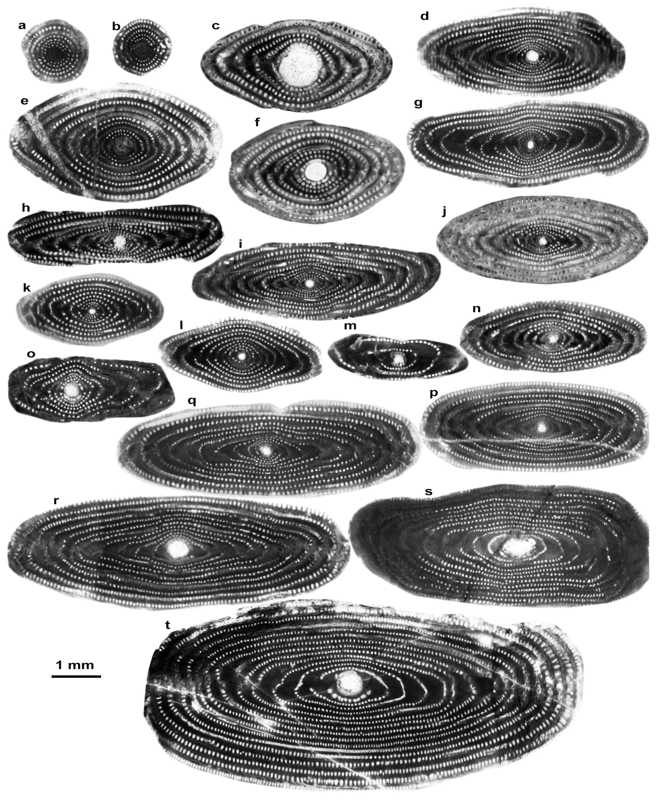
The oldest Alveolina assemblage (Fig. 8) encountered in the Val Rosandra section is composed of some index markers such as A. schwageri Checchia-Rispoli, A. canavarii Checchia-Rispoli, A. distefanoi Checchia-Rispoli, A. cremae Checchia-Rispoli and A. multicanalifera Drobne that indicate the early-middle Cuisian (upper Ypresian, SBZ10-SBZ11). Throughout the sampled interval, we have placed the upper boundary of a composite zone called SBZ10-SBZ11 at the last occurrence of A. schwageri. This would be justified by the relatively wide stratigraphic range of A. schwageri that, even though considered as an exclusive SBZ10 marker (A. oblonga zone; early Cuisian) by Hottinger (1974) and Serra-Kiel et al., (1998), it is recurrently reported throughout the early-middle Cuisian (SBZ10-SBZ11) of the AdCP and Turkey as well (see Drobne, 1977; Hottinger & Drobne, 1988; Drobne & Trutin, 1997; Sirel & Acar, 2008). Full SBZ11 is characterized by the co-occurrence of Glomalveolina cf. minutula (Reichel), A. cremae, A. distefanoi, A. multicanalifera, A. canavarii, A. decastroi Scotto di Carlo, A. cf. ruetimeyeri Hottinger and other larger Foraminifera such as Nummulites sp., Orbitolites sp., Ranikothalia sp. The boundary among SBZ 11/12 is defined at the appearance of A. rakoveci Drobne, which is considered an endemic “Adriatic” species (Drobne et al., 2011). SBZ 12 is thus also defined by the co-occurrence with A. cf. colatiensis Drobne, A. cremae, A. canavarii, as well as nummulitids (Nummulites and Operculina), and orthophragminids in the upper section. Among the rotaliids and the other encountered lamellar perforated species, Rotalia trochidiformis (Lamarck), Slovenites sp., Linderina sp., Neorotalia cf. litothamnica (Uhlig), Eponides sp. (Fig. 9) and Ornatorotalia spinosa Benedetti, Di Carlo & Pignatti span through most of the section and represent a distinctive Lower-Middle Eocene assemblage with a relatively poor chronostratigraphic resolution, when compared with Alveolina (Benedetti et al., 2011; Hottinger, 2014). The occurrence of planktonic foraminifera identified as Acarinina cf. praetopilensis (Blow) in the uppermost portion of the section suggests an assignment to the E7-E8 plankton zones (lower Lutetian) according to the scheme of Berggren & Pearson (2005) against the GTS (Gradstein et al., 2012), which is in accordance with the data showed from the northern AdCP by Ibrahimpašić et al. (2015). This is also sustained by the chronostratigraphic recalibration made by Benedetti et al. (2023) which suggests SBZ12 extends into the lower Lutetian.
- Negative pictures of Alveolina from polished slabs. Axial, slightly oblique centered sections of megalospheric Alveolina from the Val Rosandra section (Adriatic Carbonate Platform): (a, b) Glomalveolina cf. minutula (Reichel), sample VR34/1; AC11/1. (c-f) A. cremae Checchia-Rispoli, samples VR9; VR25; VR58, 5; AC11/2. (g-i) A. distefanoi Checchia-Rispoli, sample VR7/5; VR9/41; VR32/2. (j) A. schwageri Checchia-Rispoli, VR 33/2. (k, l) A. decastroi Scotto di Carlo, sample VR33/1; VR43/1. (m) A. canavarii Checchia-Rispoli, sample VR20/3. (n) A. cf. ruetimeyeri Hottinger, sample VR17/1. (o) A. multicanalifera Drobne, sample VR9/50. (p) A. cf. colatiensis Drobne, sample VR58/2. (q-r) A. frumentiformis Schwager, sample AC58/1-AC59/1. (s) A. histrica histrica Drobne, sample AC27/1; AC71/2. (t) A. rakoveci Drobne, sample VR50/1.
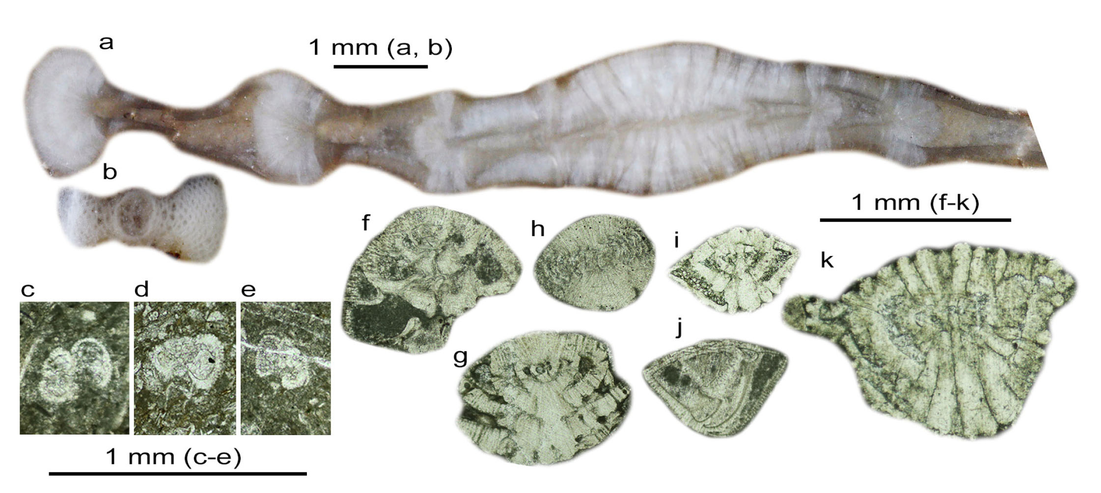
- Fig. Associate foraminiferal fauna from Val Rosandra gorge - (a) Ranikothalia sp. polished slab, sample AC70-2. (b) Orbitolites sp. polished slab, sample VR42. c) Globigerinidae, sample VR61. (d, e) Acarinina cf. praetopilensis, sample VR74 and VR75. (f) Rotalia trochidiformis, sample VR65. (g) Slovenites sp. sample VR15. (h) Linderina sp. VR65. (i) Neorotalia cf. litothamnica, sample VR68. (j) Eponides sp. (or Sanetschella Ferrandez-Canadell and Baumgartner-Mora), sample VR64. (k) Ornatorotalia spinosa, sample VR60.
Bedding and faults assemblage
Using the software Openplot, 174 bedding attitudes and 80 planar faults segments were extracted from the 3D model (Fig. 5b). These geostructural data highlight that poles to bedding are distributed along a NE-SW direction (Fig. 10a), defining an NW-SE oriented anticline structure that is coherent with the general NE-SW shortening direction of the External Dinarides (Korbar, 2009; de Leeuw et al., 2012). The poor clustering of the poles to bedding is explained by the poor cylindricity of the fold. Data evidence that the vast majority of faults are at very high angles to bedding and with a predominant NE-SW strike (Fig. 10b). A few NE dipping reverse faults are also observed (Fig. 10b), although not along the sampled track that was in fact chosen for its apparent stratigraphic continuity. Mapped normal and strike-slip faults also seem to not impact the integrity of the sampled stratigraphic section.
- Lower hemisphere equal-area projections of cumulative density contour of poles to bedding (a) and to faults and fractures (b). DN is the data number.
Bedding planes were used to produce perpendicular-to-bedding orthoimages (here also referred to as properly oriented orthoimages) and, based on those orientations, to calculate true stratigraphic thickness between each sampling point pair. Results indicated that in the field the log was underestimated by about 14 metres, which is a 9.6% discrepancy to the total thickness (Supplement 3).
DISCUSSION
The depositional history of the Paleogene carbonate succession of the Kras-Carso, likewise those placed along the Adriatic segment of the AdCP (sensu Korbar, 2009), was markedly influenced by the evolving SW-verging External Dinaric orogen (see Tari, 2002; Otoničar, 2007; Korbar, 2009, and references cited herein). In accordance with the model proposed by Sabbatino et al. (2021), this succession represents the syn-orogenic deposition within the distal setting of the foredeep depozone not yet reached by the siliciclastic input. During Eocene times, these shallow-water carbonate systems stand at the final stages of their development with successive drowning - marked by the deposition of the siliciclastic units - caused by the accelerating flexural subsidence related to the development of the Dinaric fold-and-thrust belt and foreland basin system (e.g., Otoničar 2007; Korbar, 2009; Balling et al., 2021). Throughout most of the Eocene, the stratigraphic evolution of syn-orogenic shallow-water successions of the AdCP, including the Kras-Carso, was governed by the response to the migrating orogenic belt and foreland basin system at a local scale. For instance, on the Dalmatian coast of Croatia, shallow-water carbonate deposition persisted until the Bartonian (Babić & Zupanič, 2016; Ćosović et al., 2018), whereas in northern Istria it continued just up to the lower Lutetian (see e.g., Fig. 3 of Ćosović et al., 2004) until its final drowning. Mrinjek et al. (2012) suggest that these variations depend on the local timing of syndepositional tectonic deformations.
The Val Rosandra succession displays a deepening upward evolution with a facies trend that can be considered as a classical example of development and later drowning of the lower Eocene succession of the “miliolids, Alveolina and Nummulites” unit in the Kras-Carso (see also Fig. 5 of Španiček et al., 2017). It records a Ypresian to lowermost Lutetian (SBZ 10-12) shallow-water carbonate deposition ranging vertically from an inner ramp to a mid-to-outer ramp setting within the lower photic zone, and ends with lower Lutetian hemipelagic facies referable to below the photic zone, then covered by the marls of the “Transitional beds”. The timing of vertical evolution constrains the drowning event of the carbonate factory in the studied section. This is in agreement with the data coming from northern Istria (Ćosović et al., 2004) and with previous studies made on the Val Rosandra gorge succession (Pavlovec, 1985; Drobne et al., 2009; Ibrahimpašić et al., 2015), and can be related to the large syn-tectonic influence of the Dinaric orogeny. Unlike the aforementioned works, however, the model derived from our biostratigraphic study at Val Rosandra slightly rejuvenates the age of the upper portion of platform deposits therefore postponing the drowning event in the area. This is supported by the chronostratigraphic recalibration of Benedetti et al. (2023) on SBZ12 and the occurrence of E7-E8 biozonal elements, which suggest that the upper part of the Val Rosandra succession can be fairly placed, at least, into the lowermost Lutetian. The demise of the carbonate factory is marked by the marls belonging to the “Transitional beds″ - also called in some areas “Globigerina marls” - which have been dated, nearby Val Rosandra, as early to middle Lutetian, within the NP15/16 biozones (Pavšič & Peckmann, 1996). The siliciclastic deposition recorded by the “Trieste flysch” has been dated as early to middle Lutetian, as within the NP14/16 biozones (Bensi et al., 2007; Cucchi & Piano, 2013).
The visual support received during the fieldwork effectively improved the rock sampling activities, including the precise geotagging of sample positions. Contextually, the collection of a tagged photographic dataset of the section enabled the application of structure from motion–multiview stereo digital photogrammetry for generating a virtual outcrop model in support of this biostratigraphic investigation. The virtual outcrop model was particularly useful to recalculate the true stratigraphic thicknesses. In fact, even though thicknesses were thoroughly measured in the field using a metre tape, discrepancies with stratigraphic thicknesses estimated from the 3D model were found (Fig. 7). 132-metre-thick log results from field measurements whereas a section thickness of 146 metres is calculated from the oriented orthoimages. Such 9.6% total difference is not negligible and may have significant impact in estimating sedimentological parameters such as sedimentation rates. The reasons of this discrepancies can be found in the working conditions. Some parts of the section were particularly difficult to walk, and sometimes the closeness to the outcrop hindered the recognition of the bedding attitude that changes along the section due to a different structural position with respect to the mapped fold (Fig. 5b). Comparison of hand-measured log and 3D model-derived log also highlights major changes in the vertical distribution of samples between samples VR35 and VR43 (Fig. 7), as well as an evident stratigraphic thickness discrepancy between the samples VR60 and VR61, where strata are affected by a major tilting. It is worth mentioning that the observed discrepancies only affected the thickness of strata while the virtual outcrop model analysis did not evidence any structural change such as in the stratigraphic polarity. Moreover, the occurrence of the discontinuities mapped along the virtual outcrop model of the exposure (i.e., fractures and faults in figure 5b) can be considered a minor disturbance in the stratigraphic continuity of the section.
The outcrop studied in this work belongs to the sheet n.110 (Trieste) of the geological map of Italy at 1:50,000 scale, realized in the frame of the CARG geological mapping project. As a final remark, we would like to point out that, the presented case history may represent an interesting concept for data collection and integration in the CARG geodatabase (see e.g., Battaglini et al., 2022). For instance, each sample feature, including its coordinates, lithology, palaeontological content, and stratigraphic placement is directly linked to the 3D model. The model, which is already made available online, can possibly be included in official databases (e.g., the CARG database) so that all data gathered from it will be made officially available to the public. It is worth pointing out, however, that even though sharing of 3D models can be viewed as positive for the public, the routine inclusion of virtual outcrop models in cartography projects similar to CARG, would require the definition of standardized workflows to guarantee proper quality standards. This could be achieved by issuing shared guidelines to be included in official databases (e.g., Buckley et al., 2022). In addition, virtual outcrop models are a very effective way to document and preserve outcrops (Burnham et al., 2022; Corradetti et al., 2022), which could be modified or even destroyed by natural or anthropic causes and therefore hold great potential for geological cultural heritage preservation and geoscience in general. Moreover, virtual outcrop models represent the milieus for augmented accessibility, inclusivity, and scientific reproducibility (Burnham et al., 2022; Cawood et al., 2022) as well as to deliver virtual field trips (Cliffe, 2017; Pugsley et al., 2022).
CONCLUSION
The stratigraphic distribution of the larger Foraminifera, and secondarily planktonic foraminifera, recognized in the Val Rosandra gorge have allowed for dating the Eocene shallow-water succession of the “miliolids, Alveolina and Nummulites limestone” unit (of the geological sheet n. 110 Trieste) in detail. The vertical evolution of facies displays a deepening upward trend throughout the upper Ypresian-lower Lutetian, with a final demise of the carbonate factory that is consistent with the advance of the foreland basin of the Dinaric orogen front. Field activities such as sampling and measurement of the stratigraphic section were supported by the use of a drone and virtual outcrop modeling. This has permitted us to (i) place with a precision never attained each sample on its own sampling point, along the stratigraphic succession and on each sampled limestone bed; (ii) control the biases given by the hand measurements of beds through walking survey against their relative thickness corrected by using oriented orthoimages; (iii) produce a consistent 3D model for the studied outcrop. Results coming from this survey may provide a useful concept to be further explored for enhancement of the CARG database with additional digital information that could be provided by the routine application of virtual outcrop modeling in the study of stratigraphic sections.
ELECTRONIC SUPPLEMENTARY MATERIAL
This article contains electronic supplementary material which is available to authorised users.