
INTRODUCTION
The Maltese Islands offer an outstanding opportunity for geoscientific exploration due to their intricate tectonic history, palaeogeographic evolution, sensitivity to climate variations, and spectacular landforms. The Islands are strategically positioned in the centre of the Mediterranean Sea, at the convergence of the African and Eurasian plates (Galea, 2019), within a highly faulted platform that extends as far as eastern Sicily (Colica et al., 2021), representing a focal point of tectonic activity in the central Mediterranean Sea.
The Maltese landscape is characterised by gentle, stepped slopes, marked by extensive sedimentation of limestone dating from the Late Oligocene and Miocene (Gauci & Scerri, 2019; Scerri, 2019). The current geography and landforms of the Maltese Islands have been shaped through a series of repetitive processes that have caused their emergence from the sea and subsequent submergence in relation to the Quaternary glacial and interglacial cycles. Remarkable evidence of landforms inherited from the Last Glacial Maximum (LGM) can be found both onshore and offshore (Micallef et al., 2013; Prampolini et al., 2017, 2019, 2021; Soldati et al., 2018). The Islands’ configuration became similar to the present one starting from ca. 11,000 years ago, as a result of post-glacial sea-level rise (Furlani et al., 2013; Micallef et al., 2013; Foglini et al., 2016).
The palaeogeographic evolution of the Maltese Islands position them as a crucial study site for understanding the potential effects of past and current climate variations. The Islands’ location in the centre of the Mediterranean Sea makes them sensitive to climate changes and crucial when it comes to unravelling their complexities (Carroll et al., 2012).
Throughout history, a multitude of scholars have been attracted to the Maltese Islands because of their fundamental geological importance. The foundations for understanding the geology, palaeontology and tectonics of the Maltese Islands were laid by a number of geoscience pioneers (cf. Zammit-Maempel, 1989) who devoted themselves to the exploration and study of this region, leaving a lasting legacy in the scientific literature. Among them, Thomas Abel Brimage Spratt – vice-admiral, hydrographer and geologist – is recognised as the “father of Maltese geology”; he classified rock formations in a paper that included detailed descriptions of Maltese stratigraphy (Spratt, 1843, 1854), identified the “Great Fault of Malta”, and conducted excavations that revealed remains of different fauna bones (Spratt, 1867a, 1867b). Sir William Reid – fellow of the Royal Society of London, knight commander of the Honourable Order of the Bath, knight grand cross of St. Michael and St. George, major general of his majesty’s army and governor-in-chief of the Island of Malta and its dependencies – promoted geological studies, published valuable material, including a reprint of Spratt’s work on the geology of the Maltese Islands (Reid, 1854). Sir Reid understood the relevance of exploring the geological setting of the Islands for addressing the challenges in water supply. Andrew Leith Adams – deputy surgeon-general, professor and naturalist – discovered the Maghlaq Fault, created one of the first colour geological maps of Malta, published in 1870 and expanded in 1874, studied Tertiary rock formations extensively by publishing four papers between 1863 and 1864, and described Pleistocene fauna in a series of papers published in 1866 and 1879. John Henry Cooke, naturalist and English teacher, contributed to the current knowledge of Tertiary rock formations (Cooke, 1889, 1891, 1893b), fossils (Cooke, 1890, 1893a, 1893c, 1896a, 1896b) and the Globigerina Limestone Formation (Cooke, 1896a, 1896b); moreover, his work on the Ghar Dalam Cave (Cooke, 1893a) enriched the understanding of Maltese geology and palaeontology.
The geoscientific literature on the Maltese Islands was not as rich during the first half of the 20th century, if compared to earlier periods, likely due to the occurrence of the two world wars. However, the second half of the 20th century witnessed a renewed interest in geoscientific research on the Islands.
In 1993, the Maltese Islands were provided with a geological map published by the Oil Exploration Directorate. This map covers the entire country and includes three geological sections and a description of the lithology at member level. Recently, an updated 1:10,000 digital version of the previous map was produced (Continental Shelf Department Malta, 2022a); the map comprises seven layers: subsurface geology, surface geology, artificial geology, faults, folds, solution subsidence features and bedding measurements (Continental Shelf Department Malta, 2022b).
The long-standing geoscientific interest in the Maltese Islands have recently been reinforced by the clear and emerging link between environmental sustainability needs and the establishment of policy actions. The geosciences workforce has proved to be capable to provide the necessary knowledge to effectively face contemporary environmental needs, thereby promoting the advancement of sustainable development based on the protection and conservation of the ecosystem.
The primary objective of this paper is to provide a comprehensive review of the extensive geoscientific literature related to the Maltese Islands and surrounding submarine regions. By synthesizing existing research findings, this paper aims to offer a complete geological background to scientists, professionals and technicians who are currently conducting research, or involved in land planning and management in Malta, as well as those who might do so in the future. Furthermore, the paper aims at showing how attention and interest to different geoscience fields has evolved through time.
PHYSICAL SETTING
The Maltese Islands, comprising Malta, Gozo and Comino, are located in the central Mediterranean Sea and represent one of the few emerging portions of the Pelagian Platform (Gauci & Schembri, 2019; Schembri, 2019). The stratigraphic succession of the Islands consists of marine sedimentary rocks with an approximate thickness of 250 metres. These sediments were deposited between the Late Oligocene and Miocene, forming a sequence of limestones, marls and clays subdivided into five main sub-horizontal geological formations (Hyde, 1955; Pedley et al., 1976, 1978; Pedley, 2011; Scerri, 2019) comprising Lower Coralline Limestone, Globigerina Limestone, Blue Clay, Greensand and Upper Coralline Limestone (Fig. 1 (B)).
- (A) Geographical and tectonic setting of the Maltese Islands (modified after Prampolini et al., 2017). (B) Geological sketch map of the Maltese Islands (Oil Exploration Directorate, 1993; Continental Shelf Department Malta, 2022b). The Greensands Formation is not depicted in the map due to scale issues.
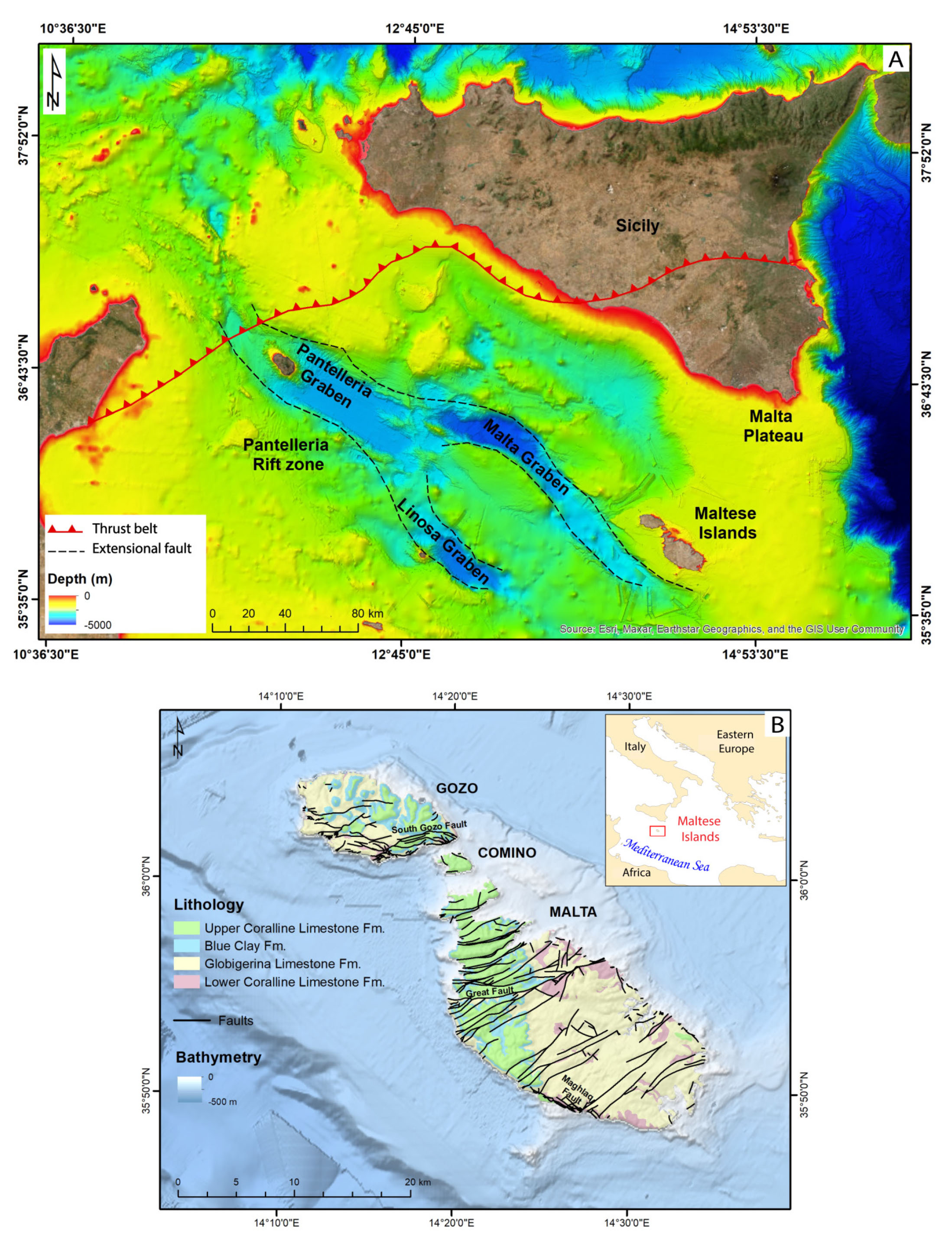
The structural framework of the Maltese Islands (Fig. 1) is influenced by two fault systems, which are a consequence of the tectonic processes affecting the central Mediterranean, as elucidated by Biolchi et al. (2011). The oldest fault system, dating back to the early Miocene, has a WSW-ENE orientation and is the result of regional stress relief, which led to the characteristic horst and graben topography observed in the Maltese Islands (Galea, 2019). The main manifestations of this system are the Great Fault and the South Gozo Fault (Baldassini et al., 2017). The more recent fault system, which originated between the late Miocene and early Pliocene, is still active and has a NW-SE orientation. It controls the Malta, Pantelleria and Linosa grabens resulting in the Pantelleria Rift Zone and defining the topography of the seabed in the area between Sicily and Tunisia. Its most evident feature is the Maghlaq Fault (Illies, 1981; Jongsma et al., 1985; Reuther & Eisbacher, 1985; Dart et al., 1993). The Maltese Islands can be classified into three primary structural regions: the Malta Horst, the North Malta Graben and, on the Island of Gozo, the Gozo Horst (Pedley et al., 1976, 1978; Scerri, 2019).
MATERIALS AND METHODS
In order to explore the geoscientific literature relating to the Maltese Islands, a literature search that spanned the years 1843 to 2023 was conducted using widely recognised databases known for their high-quality metadata—Web of Science (WoS) and Scopus, integrated with additional information from other sources.
We considered papers with the following eligibility criteria: (i) focus on a study area including the Maltese Islands and/or the surrounding submarine regions, (ii) related to the geoscience field of research as defined by the search query mentioned below, (iii) fall into categories of articles, reviews, books, book chapters or proceedings, and (iv) to be published in English.
In the WoS, the search query applied to the ‘title’, ‘abstract’ and ‘keywords’ was: ‘Malta AND (geology OR geomorphology or palaeontology or mineralogy or physical geography or oceanography or geoheritage OR Quaternary dynamics or geography OR engineering or ecology OR archaeology or environmental science OR geochemistry or geoarchaeology or geophysics or tectonics)’. The Scopus search used a similar query, improved with the search key: ‘Malta’ OR ‘Maltese Islands’ OR ‘Maltese Archipelago’, limited to works dealing with Earth sciences. Prioritising Scopus as a research tool for the literature review was a strategic decision based on its reputation for providing a comprehensive coverage of scholarly literature across various fields (cf. Pranckut, 2021). Additionally, we consulted unpublished doctoral thesis. Furthermore, a cross reference check was performed by consulting the reference lists of the books by Pedley et al. (2002) and Gauci & Schembri (2019), regarded as compendia on the geological and geomorphological features of the Maltese Islands. A supplementary search was conducted on Google Scholar to verify that no significant documents related to the research topic were overlooked.
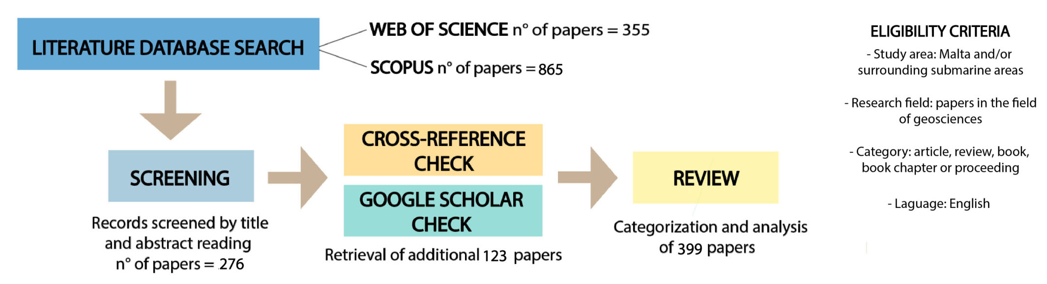
The review process entailed the following steps (Fig. 2): (i) identification of bibliographic records through Scopus and Web of Science and exporting them as BibTeX and plaintext formats, respectively; (ii) retrieval of metadata for each record using RStudio’s bibliometrix tool (Aria & Cuccurullo, 2017); (iii) screening and selection of records identified according to the above-mentioned eligibility criteria by evaluating the title and abstract; (iv) validation of the bibliographic search completeness by cross-referencing and Google Scholar checking; (v) categorisation and analysis of selected papers.
- Workflow of the literature search and relevant outputs.
The selected papers were organised in an Excel sheet (cf. Supplementary Material) including the following information:
- Presence/absence on WoS/Scopus
- Title
- Name of author(s)
- Date of publication
- Onshore/offshore/integrated study area
- Geoscience field(s)
- Type of work
- Objective
- Keywords
- Source
- Country of authors’ affiliation.
The papers were analysed based on the following aspects:
i. Geoscientific field: We assigned the selected articles to specific research themes.
ii. Time distribution: Considering the aforementioned geoscientific fields assigned to each article, we analysed the chronological distribution of the articles and computed the corresponding cumulative curves.
iii. Keyword frequency and distribution: We generated word clouds for each geoscience field by analysing the frequency of the keywords from selected papers. Only keywords that appeared in more than one paper were included in these word clouds. We included all papers with available keywords, excluding place names and the names of the respective geoscientific fields from the word lists.
iv. Location of study areas: We categorised the selected papers based on the location of the study areas into the following groups: (i) onshore, focusing on terrestrial areas; (ii) offshore, focusing on submerged areas surrounding the Maltese Islands; and (iii) integrated onshore-offshore, encompassing both the Islands and adjacent submerged regions in the descriptions and data collection. Subsequently, we analysed the distribution of these areas in relation to the corresponding geoscientific fields.
v. Scholarly collaboration metrics: Within each of the considered geoscientific fields, we derived scholarly collaboration metrics that offer insights into the degree of collaboration. These metrics cover various aspects including the count of papers, authors and their collaboration patterns. This encompasses the total number of authors for single-authored and multi-authored papers, the distribution of papers based on the number of authors, and metrics assessing the degree of collaboration. The level of collaboration is quantitatively measured using the Authors’ Collaboration Index (CI) for multi-authored papers. The latter is quantitatively defined through the Authors’ Collaboration Index (CI) of the Authors of multi-authored papers. The CI is calculated as the ratio between the number of Authors of multi-authored papers and the number of Multi-authored papers (Ardanuy, 2012; Campra et al., 2020).
vi Country of authors’ affiliation and networking: We constructed a country collaboration network based on co-authorship. This network was generated using papers obtained from WoS and Scopus, where information of authors’ country affiliations was available as metadata. The country collaboration network plot was created using R Studio (version 2023.06.0; RStudio Team, 2023), the integrated development environment for R (version 4.3.1; R Core Team, 2023).
LITERATURE REVIEW OUTPUTS
A total of 355 papers were retrieved from WoS and 865 from Scopus. Among these, 276 papers (excluding duplicates) met the eligibility criteria used for the screening based on titles and abstracts readings. Cross-reference checking added 114 papers, and the Google Scholar checking confirmed the comprehensiveness of literature search, revealing only 9 significant missing papers, bringing the final review total to 399 papers (Fig. 2). Special attention was dedicated to the categorisation and analysis of the papers based on the aspects listed above, with a primary focus on the geoscientific field of research.
Geoscientific field
We identified 16 research themes, reported below in alphabetical order, and assigned to them the selected papers:
- Engineering geology
- Geoarchaeology
- Geochemistry
- Geoheritage
- Geomorphology
- Geophysics
- Georesources
- Historical geology
- Hydrology and Hydrogeology
- Mineralogy
- Oceanography and Marine geology
- Palaeontology and Palaeoecology
- Petrology
- Stratigraphy and Sedimentology
- Structural geology
- Multidisciplinary (including also significant contents outside geosciences; e.g., ecology, environmental and climate issues).
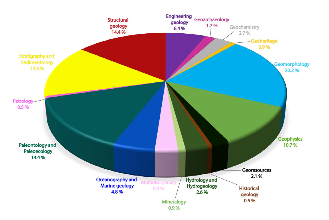
Our analysis reveals that 150 papers deal extensively with more than one geoscientific field (see Fig. 3). Geomorphology is the largest segment of the papers found, accounting for 20.2% showing an increased interest in this field in the last decade. The field of Stratigraphy and Sedimentology accounts for 14.6%, while Palaeontology and Palaeoecology, together with Structural geology, both account for 14.4% of the papers. Geophysics follows closely, with 10.7% of the total. Engineering geology represents the 6.4% of the papers. Oceanography and Marine geology account for 4.8% of the papers. The geoscientific fields of Geochemistry, Hydrology and Hydrogeology and Georesources contribute to 2.7%, 2.6% and 2.1% respectively to the total. The field of Geoarchaeology corresponds to 1.7% of the papers. Geoheritage, Mineralogy and Multidisciplinary share the low percentage of 0.9. However, the interest for geoheritage showed a remarkable increase in recent years. Historical geology and Petrology have a minimal presence, each representing 0.5% of the overall distribution.
- Classification of papers based on their main geoscientific field.
Time distribution
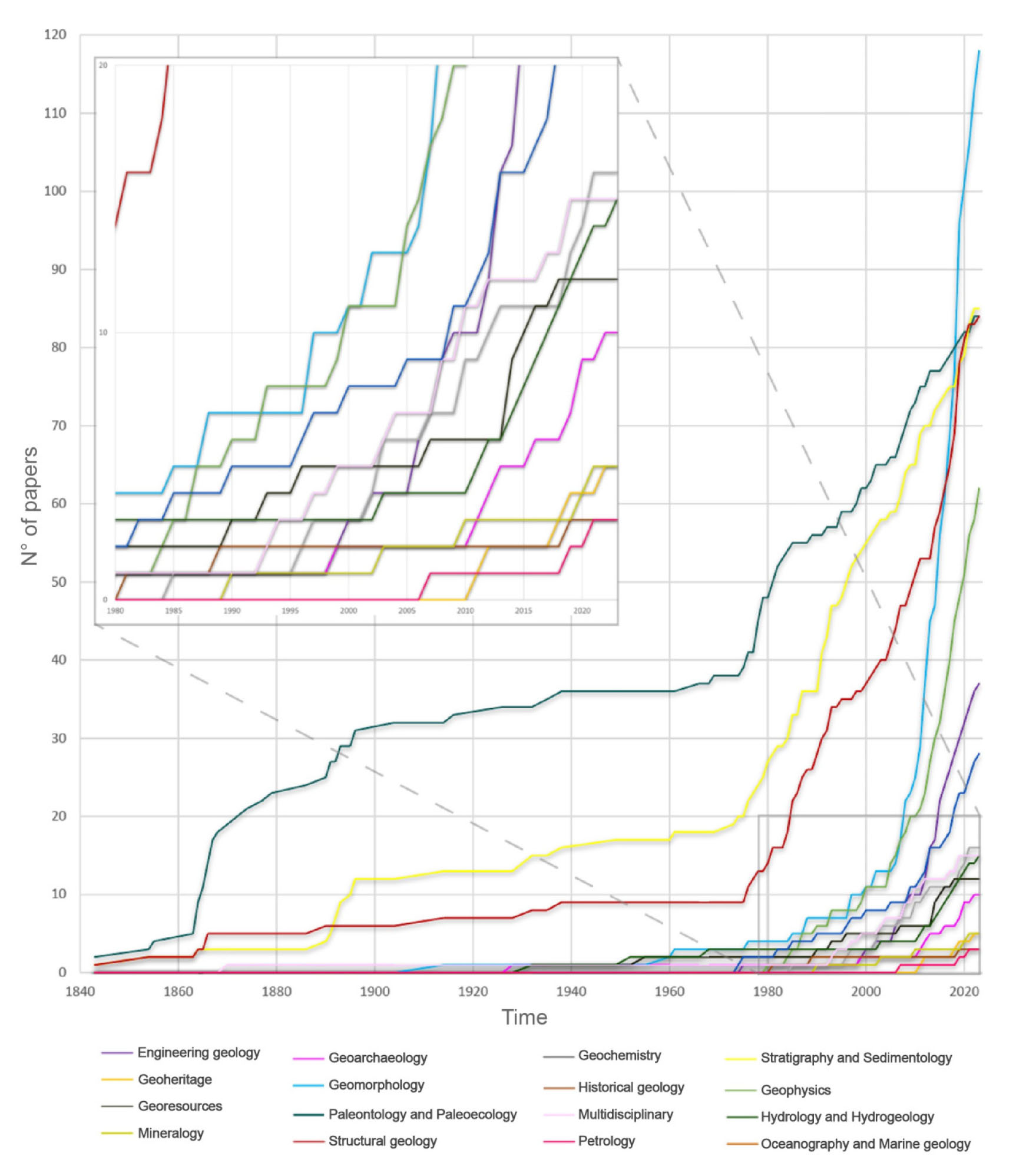
We carried out an analysis of the temporal distribution of publications with reference to the geoscientific fields outlined above (Fig. 3). We computed cumulative curves (Fig. 4) that show a general increasing trend of publications about the Maltese Islands, for the timeframe considered. The graph highlights diversified trends among geoscientific fields showing an increasing interest in Geomorphology, which has gained momentum during the last decade. In the field of Palaeontology and Palaeoecology, there is a notable activity between 1860 and 1900 followed by near stability until 1970, after which there has been a significant growth to the present day. The field of Stratigraphy and Sedimentology shows two major peaks, one around 1890 and the other between 1980 and today. Structural geology seems to have attracted most interest since the late 1970s, while attention to Geophysics and Engineering geology have been increasing in the last two decades. The zoomed in inset shows other research fields with a slower increase rate (Fig. 4).
- Cumulative number of papers per year per each geoscientific field.
Keyword frequency and distribution
We generated word clouds (Fig. 5) for each geoscience field based on the frequency of keywords from selected papers. The word clouds included keywords that appeared in more than one paper. Word clouds provide a quick and visual representation of prominent keywords, aiding in the identification of key themes across the reviewed papers.
- Word clouds generated for each geoscientific field, utilizing keywords extracted from the selected papers. The reported keywords are those that recurred in more than one paper (i.e., with an occurrence frequency exceeding one).
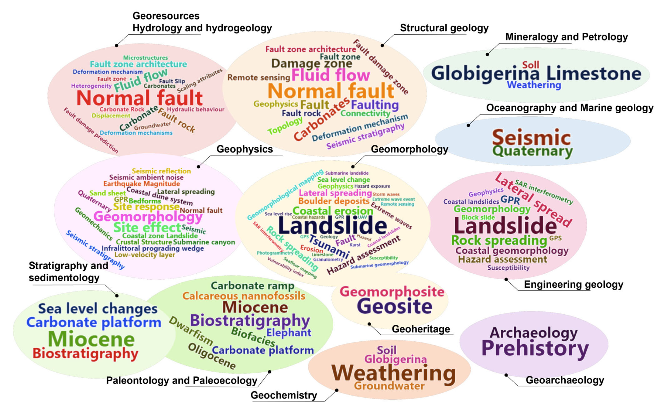
The size of words in the cloud is proportional to their frequency, aiding in discerning which concepts and thematic areas received greater emphasis in the analysed literature. This approach enabled the identification of geoscientific fields sharing similar keywords.
Keywords associated with Hydrology and Hydrogeology have some overlap with those of Structural geology, including terms such as ‘normal fault’, ‘carbonates’, ‘fluid flow’, ‘fault zone’, ‘fault zone architecture’, and ‘deformation mechanism’. In addition, the keyword ‘normal fault’ is shared with Geophysics. The latter shares terms such as ‘lateral spreading’, ‘landslide’ and ‘GPR’ with Geomorphology. Geomorphology’s keywords also partially overlap with those of Engineering geology sharing terms such as ‘landslides’, ‘SAR interferometry’, ‘rock spreading’, ‘risk assessment’, ‘susceptibility’, ‘GPR’, and ‘GPS’. The geoscience fields of Geophysics and Engineering Geology include the term ‘geomorphology’ among their keywords. Stratigraphy and sedimentology share some keywords with Palaeontology and Palaeoecology, such as ‘Miocene’ and ‘biostratigraphy’.
Location of study areas
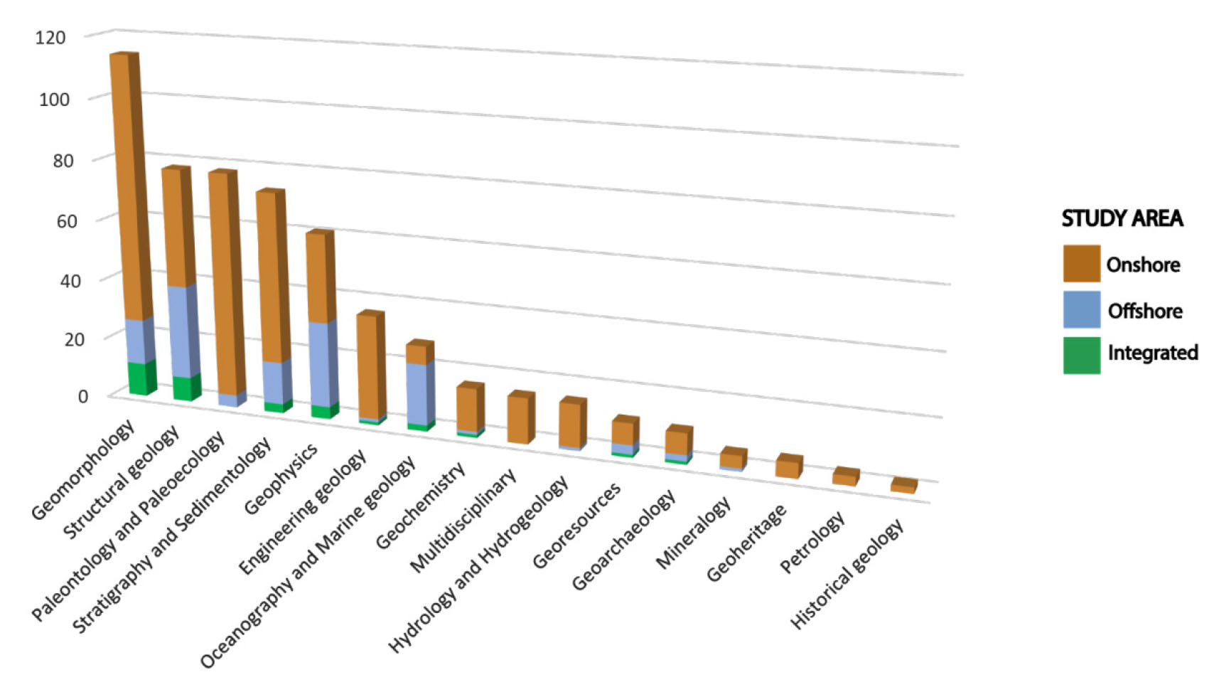
We classified the selected papers based on the location of the investigated study areas in (i) onshore, (ii) offshore and (iii) integrated onshore-offshore papers.
We then examined the distribution of these study areas with reference to the various geoscientific fields, as illustrated in Fig. 6. Research on the Maltese Islands focus on onshore study areas, with the exception of Oceanography and Marine geology. Structural geology and Geophysics are the only ones where the number of papers on onshore and offshore study areas is almost equal. Meanwhile, Multidisciplinary, Geoheritage, Petrology and Historical geology refer exclusively to onshore regions. Palaeontology and Palaeoecology, Hydrology and Hydrogeology, and Mineralogy deal exclusively with onshore and offshore areas, and no evidence of integrated terrestrial and marine data was observed. The field of Geomorphology presents the largest number of papers integrating terrestrial and marine datasets.
- Distribution of papers based on the location of study areas, i.e., onshore, offshore and integrated onshore-offshore.
Scholarly collaboration metrics
Scholarly collaboration metrics provides insights into the collaboration degree within each of the considered geoscientific fields. With reference to single disciplines, we did not consider multiple authorships of a given author in the total count. For instance, if a single author contributed to multiple papers within a specific geoscientific field, that author was considered only once, ensuring that individual authors were not double-counted based on the number of papers they published. This approach helped provide a more accurate representation of the number of unique authors involved in the collaborative efforts within the geoscientific field. Table 1 offers an overview of research collaboration within each geoscientific field. It includes, among other values, also the data relating to indicators derived from geoscientific fields which overall total a number of papers of less than ten (namely, Geoheritage, Historical geology, Mineralogy, Petrology). This was done to ensure a comprehensive illustration of the results of the scholarly collaboration metrics. However, the results of the collaboration metrics for the geoscientific fields that have fewer than ten papers are not described further. In fact, the low number of papers retrieved for these fields deems them non-representative for the study of collaboration.
| Geoscientific field | Engineering geology | Geoarchaeology | Geochemistry | Geoheritage* | Geomorphology | Geophysics | Georesources | Historical geology* | Hydrology and Hydrogeology | Mineralogy* | Multidisciplinary | Oceanography and Marine geology | Paleontology and Paleoecology | Petrology* | Stratigraphy and Sedimentology | Structural geology |
|---|---|---|---|---|---|---|---|---|---|---|---|---|---|---|---|---|
| Papers | 37 | 10 | 16 | 5 | 119 | 63 | 12 | 3 | 15 | 5 | 15 | 28 | 84 | 3 | 86 | 84 |
| Number of authors | 84 | 34 | 59 | 13 | 195 | 170 | 27 | 3 | 46 | 13 | 42 | 117 | 126 | 18 | 184 | 210 |
| Authors of single-authored papers | 5 | 3 | 2 | 0 | 19 | 7 | 5 | 1 | 4 | 1 | 4 | 4 | 27 | 0 | 24 | 21 |
| Authors of multi-authored papers | 81 | 31 | 58 | 13 | 186 | 167 | 23 | 2 | 43 | 12 | 40 | 114 | 108 | 18 | 164 | 195 |
| Single-authored papers | 6 | 3 | 3 | 0 | 21 | 8 | 5 | 2 | 4 | 2 | 6 | 6 | 55 | 0 | 41 | 30 |
| Multi-authored papers | 31 | 7 | 13 | 5 | 98 | 55 | 7 | 1 | 11 | 3 | 9 | 22 | 29 | 3 | 45 | 54 |
| Authors per paper | 2.3 | 3.4 | 3.7 | 2.6 | 1.6 | 2.7 | 2.3 | 1.0 | 3.1 | 2.6 | 2.8 | 4.2 | 1.5 | 6.0 | 2.1 | 2.5 |
| Authors’ Collaboration Index | 2.6 | 4.4 | 4.5 | 2.6 | 1.9 | 3.0 | 3.3 | 2.0 | 3.9 | 4.0 | 4.4 | 5.2 | 3.7 | 6.0 | 3.6 | 3.6 |
Geoscientific fields with an overall number of papers <10.
From the results presented in Table 1 and in Fig. 7, it is evident that some geoscientific fields, including Geophysics, Engineering geology, and Geomorphology, show a notable tendency to have the lowest number of single-author papers compared to the total paper count. This trend suggests a propensity towards collaboration within these specific fields.
- Visualisation of the indicators shown in Table 1, specifically relevant to geoscientific fields with a total of papers ≥ 10. The indicators include the counts of: (i) authors, (ii) single-authored papers, (iii) multi-authored papers. The Authors’ Collaboration Index (CI) is also illustrated. CI is calculated as the ratio between the number of Authors of multi-authored papers and the number of Multi-authored papers (Ardanuy, 2012; Campra et al., 2020).
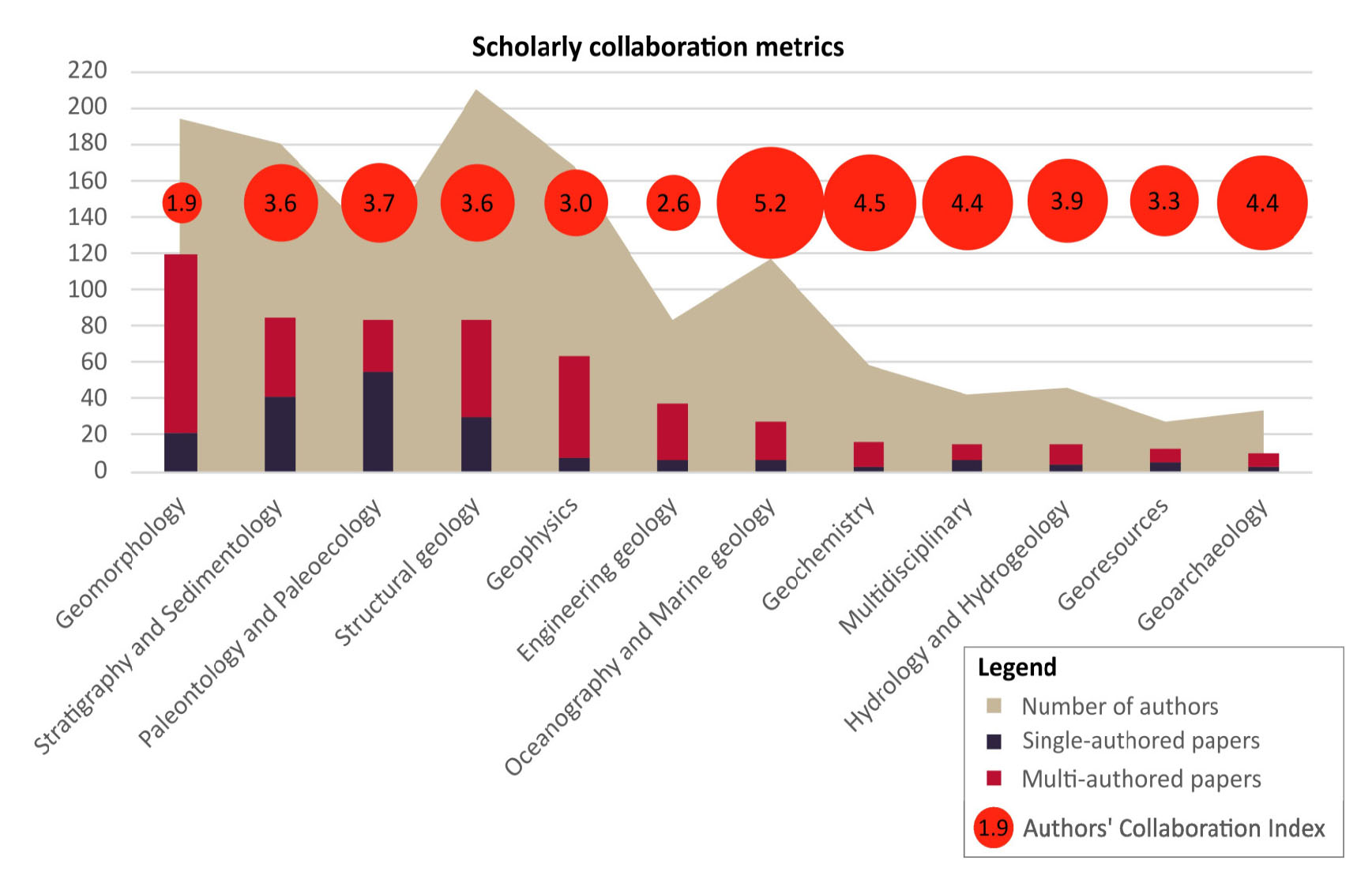
The Authors per paper indicator represents the ratio between the overall number of authors in a particular geoscientific field and the corresponding total number of papers. The highest values of this indicator correspond to fields characterised by a higher number of authors relative to the total number of papers. Greater ratios of Authors per paper may be indicative of fields where a greater number of authors collaboratively contribute to individual papers compared to the overall document count. This suggests distinct approaches to collaboration among the different geoscientific fields.
An analogous trend is shown by the Authors’ Collaboration Index, with higher values suggesting that, on average, there is a high variety of authors contributing to each multi-authored document. This could indicate a high level of collaboration within the geoscientific field implying the involvement of many different authors. A low Authors’ Collaboration Index implies that, on average, there is a fewer diversity of authors among multi-authored documents.
Examining Table 1 and Fig. 7, and focusing on geoscience fields with a total number of articles ≥ 10, which ensures the most representative indices, significant insights emerge. Geomorphology is the geoscientific field with the highest number of publications (119), frequent collaborations (98) and the lowest Authors’ Collaboration Index (1.9). Geoarchaeology has the lowest number of publications (10), shared with Geochemistry for single-author articles (3) and Georesources for multi-author articles (7). The geoscience field of Georesources, with the lowest number of authors (27), contrasts with Structural geology, on which most authors focused (210). Palaeontology and Palaeoecology stand out with the highest number of publications per single author (55). The field of Oceanography and marine geology has the highest Authors’ Collaboration Index (5.2).
Country of authors and networking
The collaboration between authors, based on their affiliation, was also analysed through a country collaboration network (co-authorship) in order to facilitate understanding of international connections (Fig. 8).
- Country collaboration network based on the authors’ affiliations. The width of the links is proportional to the number of collaborations (joint papers) between two countries.
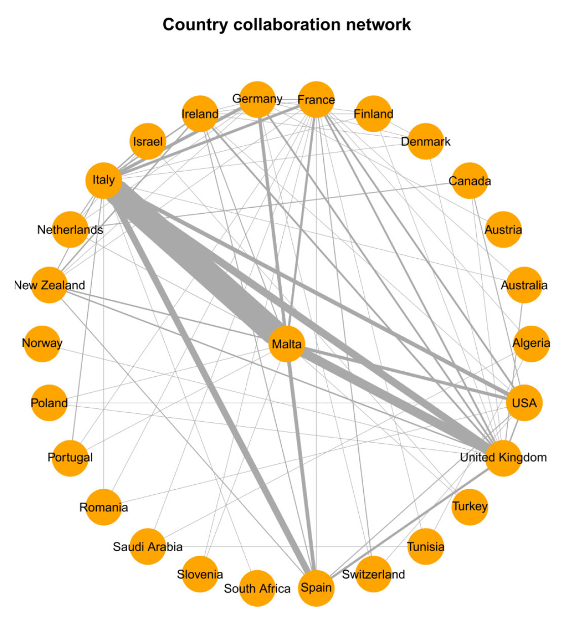
The plot highlights that the authors from Italy and the United Kingdom are those with whom Maltese geoscientists have most frequently collaborated (55 and 20 collaborations respectively). The plot distinctly illustrates the central role of scientific collaboration between Italy and Malta in this specific research domain. Spain (8 collaborations), USA (7 collaborations), and Germany (7 collaborations) show a high degree of connection with the Maltese geoscience community.
DISCUSSION
The main findings of each analysis are discussed below.
Geoscientific field
Over time, the Maltese Islands have attracted numerous scholars due to their significant geological importance. As described by Zammit-Maempel (1989), geoscientific research started in the second half of the 19th century thanks to the so-called pioneers of Maltese geology, who mainly focused on the Stratigraphy and Sedimentology of the Maltese Islands (e.g., Adams, 1863; Cooke, 1893a, 1896a), Palaeontology and Palaeoecology (e.g., Spratt, 1867a; Adams, 1879; Cooke, 1890, 1893c) and Structural geology (e.g., Spratt, 1854), which are often treated in parallel even within the same papers. Their focus was on the geological formations of the Maltese Islands, emphasising their stratigraphic features, fossil content and the tectonic mechanisms responsible for their deformation.
The first half of the 20th century saw a reduction in geoscientific publications related to the Maltese Islands likely due to the occurrence of the two world wars. However, the publications of this period were mainly focused on Palaeontology and Palaeoecology (Lemoine & Douville, 1904; Bate, 1916, 1935; Douville, 1926; Trechmann, 1938) and on Stratigraphy and Sedimentology (Hobbs, 1914; Rizzo, 1932a, 1932b; Trechmann, 1938; Reed, 1949). The second half of the 20th century marked a resurgence of geoscientific interest in the Maltese Islands which continues to produce new contributions. The increase in geoscientific attention and corresponding scientific publications related to the Maltese Islands can be attributed to a confluence of factors. Technological advances played a key role, facilitating more thorough and precise investigations. In addition, increased environmental awareness underscored the imperative to safeguard and sustainably manage ecosystems of geological and environmental importance, fuelling scholarly interest. Finally, the growing trend in the global scientific community toward international collaboration and knowledge sharing contributed significantly to the increase in research on the Maltese Islands. Our investigation revealed the importance of geomorphological investigations conducted on the Islands, especially during the last decade (Fig. 3). This research interest is mainly motivated by the Islands’ susceptibility to coastal landslides (e.g., Soldati et al., 2019; Rizzo et al., 2020; Devoto et al., 2021; Mantovani et al., 2022) and coastal erosion (e.g., Farrugia, 2017; Micallef et al., 2018; Causon Deguara et al., 2023), processes which are favoured by sea-level rise (e.g., Biolchi et al., 2011; Furlani et al., 2017; Prampolini et al., 2019; Vandelli et al., 2023), local topography and geological composition (e.g., Spratt, 1854; Pedley et al., 1976; Lorenz & Mascle, 1984). In many cases, the field of Geomorphology is treated in parallel with Engineering geology, with the aim to deepen the understanding of the previously mentioned processes and, consequently, to improve the management and planning of coastal areas. In particular, this interest has gained more importance in recent years, driven by a growing awareness of the practical implications for adaptation, mitigation measures and sustainable development issues, thus underlining the need for a more comprehensive understanding of the geomorphology of the Maltese Islands.
The field of Stratigraphy and Sedimentology is also showing considerable interest today, driven by the peculiar geological characteristics of the region. The interest is to understand the sedimentary succession in the Late Oligocene-Miocene within the Islands (e.g., Baldassini & Di Stefano, 2017; Bialik et al., 2021). In many cases, papers dealing with Stratigraphy and Sedimentology also delve into the Palaeontology and Palaeoecology, and the Structural geology of the Maltese Islands. Indeed, the latter boast a rich fossil record (e.g., Hojjatzadeh, 1978; Bosence & Pedley, 1982; Bosence, 1983; Gatt & De Angeli, 2010; Nicholl et al., 2020), providing insights on biostratigraphy (e.g., Mazzei, 1985; Foresi et al., 2002, 2007; Gruszczyński et al., 2008; Bianucci et al., 2011; Catanzariti & Gatt, 2014), past ecosystems (e.g., Cooke, 1893c; Pedley et al., 1976, 1978; Pedley, 1979; Brandano et al., 2008, 2009), biodiversity (e.g., Zammit-Maempel, 1969; Rehfeld & Janssen, 1995) and how the latter responded to environmental changes over geological time scales (e.g., Zammit-Maempel, 2007; Brandano et al., 2009). As for Structural geology, the aim is mainly to provide insights into the deformation processes that have shaped the geological framework of the Islands over time (e.g., Hobbs, 1914; Pedley et al., 2002; Scerri, 2019).
Time distribution
The cumulative curve of the number of papers in geoscientific fields over time (Fig. 4) provided a comprehensive overview of the evolution of the geoscientific research landscape on the Maltese Islands. Overall, the analysis revealed a general increase in the number of articles in all geoscientific fields, indicating a growing interest in geoscientific research in the Maltese Islands. Within specific areas, the following trends were observed:
- A significant and steady increase in the number of publications dealing with the Geomorphology over the last decade suggested a growing interest in understanding the evolution of the Maltese landscape, for the definition of adaptation and mitigation measures made necessary by the climate-related risks to which the Islands are subject;
- A peak between 1980 and the present day was evident in the field of Stratigraphy and Sedimentology, and could be related to periods of increased geological exploration or methodological advances favouring research activity in these areas;
- The special interest in Palaeontology and Palaeoecology from 1970 to the present day could be attributed to technological advances that have led to a renewed interest in discoveries in the palaeontological history of the Islands;
- A growing interest in Structural geology has been observed since the late 1970s, indicating a shift in focus towards understanding the tectonic processes and deformation history of the Maltese Islands;
- The last two decades have seen an increase in attention also in the fields of Geophysics and Engineering geology, which may reflect the contemporary emphasis on applications of adaptation and mitigation structures and in environmental monitoring;
- Recently, there has been a relatively significant increase in the number of geoheritage papers regarding the Maltese Islands (e.g., Coratza et al., 2016; Selmi et al., 2022). In the past few years, the Islands’ efforts to promote geoheritage conservation have included raising awareness of the importance of geological features, developing geotourism and implementing measures to ensure the sustainable management and protection of these valuable geological assets. These efforts are particularly important due to the challenges posed by extensive urbanisation and artificial land cover (cf. Pace et al., 2023), making the conservation and sustainable management of geoheritage a priority for the country.
The trends observed in publication activity in the different geoscientific fields offer valuable insights into the dynamic nature of scientific investigation in the Islands.
Keyword frequency and distribution
From the world clouds (Fig. 5) it emerged that researchers in Engineering geology, Geomorphology, and Geophysics demonstrate a shared interest in coastal landforms and processes (e.g., Devoto et al., 2012, 2020; Prampolini et al., 2017; Galea et al., 2018; Rizzo et al., 2020, 2022; Vandelli et al., 2023). Research within these geoscientific fields focused on coastal landslides, namely on diffused rock spreads and block slides which were not mapped and monitored until 2008 (e.g., Magri et al., 2008; Devoto et al., 2020, 2021; Mantovani et al., 2022). A number of geomorphological studies focused on extreme wave events and related deposits (e.g., Causon Deguara & Scerri, 2019; Mottershead et al., 2020). Hydrology and Hydrogeology both contributed to the examination of fluid flow within normal faults affecting the carbonate rocks of the Maltese Islands (e.g., Micallef et al., 2011; Dimmen et al., 2017). Geochemical studies primarily focused on the weathering of the limestones (e.g., Cassar & Vella, 2003; Bianco, 2021; Roussel et al., 2021). Stratigraphy, sedimentology and palaeontology collaboratively investigated the Miocene sedimentary successions (e.g., Bianucci et al., 2011; Baldassini & Di Stefano, 2015; Scerri, 2019) and carbonate platforms (e.g., Brandano et al., 2019; Bialik et al., 2021; Gatt, 2022). Geoscientific research appeared extremely interconnected, highlighting the considerable potential for collaboration and interdisciplinary research, which are essential for deepening the understanding of complex geological phenomena.
Location of study areas
The literature analysis revealed that most of the studies were focused on onshore areas. This reflected especially in the early geoscientific production regarding the Maltese Islands witnessed by the pioneeristic studies carried out in the 19th century (Zammit-Maempel, 1989). However, when dealing with Structural geology and Geophysics, an equal interest emerged for both onshore and offshore regions. In particular, Structural geology exhibited a certain interest in submarine structural and tectonic features, notably those situated in the Sicily Channel, encompassing the Malta Plateau and Escarpment, the Pantelleria Graben, the Malta Graben and the Linosa Graben, which are among the main tectonic structures in the Central Mediterranean Sea (Fig. 1A). Additionally, quite a large number of geomorphological studies focused on the submerged landscape of the Maltese seabed (e.g., Foglini et al., 2016; Prampolini et al., 2018, 2019). Turning attention to Geophysics, its methodologies, particularly those involving sonar sounding systems and seismic reflection techniques, played a pivotal role in deciphering submerged features and/or onshore areas (e.g., D’Amico et al., 2022).
It is widely recognised how integrating terrestrial and marine datasets can be beneficial in geo-environmental studies (Prampolini et al., 2020). Nevertheless, the literature review reveals that only a limited number of studies embraced this integration. Thus, there is a clear opportunity for future endeavours to focus on advancing this direction. Another opportunity arises from the potential for acquiring novel insights into the unexplored submerged geoheritage of the Maltese Islands, as documented for other Mediterranean submarine areas (cf. Coratza et al., 2019).
Scholarly collaboration metrics
The outputs of the scholarly collaboration analysis revealed that most of the investigated literature is the result of a collaborative effort. Among other indicators included in Table 1 and Fig. 7, the Authors’ Collaboration Index provided a quantitative measure of the collaboration degree within a specific geoscientific field. It was calculated as the ratio between the number of Authors of multi-authored papers (eliminating authors’ repetitions) and the number of Multi-authored papers (cf. Literature review outputs). A high Authors’ Collaboration Index implied a rich diversity of authors contributing to multi-authored papers in a specific geoscientific field. This diversity suggested a broad spectrum of expertise and methodologies involved in a certain field of the geoscientific research, as in the case of Oceanography and Marine geology, Geochemistry, Geoarchaeology and Multidisciplinary studies. A low Authors’ Collaboration Index may suggest a narrower range of authors involved in multi-authored papers. This is the case of the Geomorphology geoscientific field where there was a clear opportunity to enhance collaboration by expanding the author network including diverse perspectives and interdisciplinary approaches.
Country of authors and networking
The examination of the collaboration network among countries, as detailed in the Literature review outputs, revealed that the authors with Maltese affiliation most frequently collaborate with scientists from Italy and the United Kingdom in the field of geosciences. The geographic proximity of Italy and Malta may favour exchange among scientists, facilitating logistical aspects of collaboration. The linguistic connection adds another layer to this collaboration. The historical use of Italian as the third language in Malta, and its status as an official language until 1936 (Caruana, 2013), likely facilitated the communication and collaboration between Italian and Maltese scientists. The current economic and tourism exchanges between Italy and Malta may play a role in enhancing further scientific collaboration. Italy’s position as the third-largest import partner for Malta (The Observatory of Economic Complexity, 2023) reflects a robust economic relationship. The significant number of Italian tourists, second only to UK tourists (OECD, 2022), may provide opportunities for cultural and scientific exchanges. Additionally, Malta serves as a favoured destination for Italian students attending English language courses, further enriching the multifaceted nature of Maltese-Italian collaboration. It is worth mentioning that this comprehensive collaboration extends beyond geographic, linguistic, and economic connections, encompassing a close political relationship evident through official exchanges and bilateral agreements (Caruana, 2013).
Similarly, the intense collaboration between Malta and the United Kingdom could be attributed to historical factors as well, specifically Malta’s status as a British colony until its independence in 1964 (Schembri et al., 2020). This historical connection is further emphasised by the enduring influence of the English language, which continues to be one of the official languages of Malta. The shared history and linguistic ties likely contribute to the robust scientific collaboration observed between Malta and the United Kingdom, reflecting a historical continuum of scholarly exchange.
CONCLUSIONS
This review provides a compendium of resources for those interested in working in the geosciences targeting the Maltese Islands. The Maltese Islands occupy a central position in the Mediterranean Sea, serving as a focal point for the understanding of geotectonic activity and palaeogeographic evolution. With a rich geological record, they offer insights into the dynamic interplay of geological processes that have shaped the region over time. The Islands’ susceptibility to climatic fluctuations, highlighted by evidence of post-glacial sea-level rise, underlines the urgency of developing sustainable coastal management strategies in the broader context of the Mediterranean. The review outcome highlights that most of the research so far is related to the field of Geomorphology, Stratigraphy and Sedimentology, Palaeontology and Palaeoecology, and Structural geology. Most of the work carried out so far entailed collaborations between the Maltese academic institutions, along with UK and Italian research institutes. This sheds lights on the collaborative and international breath that characterise the research environment in Malta, but also on the need to broaden the Maltese research interests to pan European and international projects. New technologies and the need to tackle complex research questions with interdisciplinary and multidisciplinary methodologies will pave the road for further investigations that can bridge the current research gaps such as integrating terrestrial and marine research, geoheritage and oceanographic studies, seafloor surveying studies of the Maltese shelf, along with groundwater explorations.
ELECTRONIC SUPPLEMENTARY MATERIAL
This article contains electronic supplementary material available in open access. The supplementary data provide detailed information on the 399 papers analysed and commented in this review including their categorisation based on the following aspects: (i) Geoscientific field, (ii) Time distribution, (iii) Keyword frequency and distribution, (iv) Location of study areas (onshore, offshore, integrated research), (v) Country of authors’ affiliation and networking, (vi) Scholarly collaboration metrics.